|
||

|

|
|

|
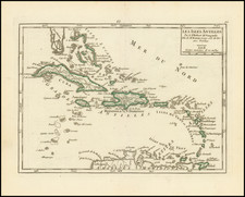
Finely executed Spanish Sea chart of Florida and the Bahamas, published by the Spanish Hydrographical Survey in 1867.
As noted by the title, the map is a combination of Spanish and foreign sources. The detail in South Florida and the Florida Keys includes nearly a dozen lighthouses. The southwest tip of Florida is a marvelously scrambled archipelago, providing a fascinating depiction of the Everglades. Lago Kee Cho-Bee or Big Water is well delineated.
The mapping of the Bahamas is also quite advanced and includes hundreds of soundings and sailing directions.
A fine example of this scarce chart.
The Dirección de Hidrografía, or the Directorate of Hydrographic Works, was established in 1797. Its roots were in the Casa de Contratación, founded in 1503 in Sevilla, which housed all the charts of the Spanish Empire and oversaw the creation and maintenance of the padrón real, the official master chart. The Casa, now in Cadiz, was shuttered in 1790, but Spain still needed a hydrographic body. In response, the Dirección was created in 1797. One of its first projects was the publication of charts from the Malaspina Expedition (1789-1794). The Dirección oversaw not only publication, but also surveying. The Dirección was abolished in the early twentieth century, when their work was distributed to other organizations.
![[Florida Indians / Hermaphrodites] Hermaphroditorum officia. XVII.](https://storage.googleapis.com/raremaps/img/small/97966.jpg)
![Memoir on the Geography, and Natural History and Civil History of Florida, attended by a Map of that Country, Connected with the Adjacent Places: and an Appendix, Containing the Treaty of Cession, and other Papers Relative to the Subject [with:] Map of Florida](https://storage.googleapis.com/raremaps/img/small/81777.jpg)