|
||

|

|
|

|
A fine example of Dufour's wall map of North America, which also appeared in a rare early edition of Andriveau Goujon's Atlas Choix…, an elephant folio atlas of wall maps selected by Andriveau Goujon to illustrate the most up to date cartography of the period.
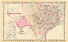
Texas is shown as a Republic, with many of the early towns and settlements located, along with Ft. Matagorda. The treatment of Alta California and the Rocky Mountains region is one of the best of the period, integrating the best available pre- Fremont cartographical information, including the reports of Jedidiah Smith. The Northwest and Rocky Mountain regions are extremely detailed, with the 54-40 or fight Oregon Territory clearly in evidence. The British Forts north of the 42nd Parallel are shown. The second mythical Salt Lake is present, but not linked to the west coast by any river. Extensive Indian details are shown.
One of the most interesting large format maps of the pre-Fremont, post Lewis & Clark era.
![[Matagorda Bay] Bahia De S. Bernardo](https://storage.googleapis.com/raremaps/img/small/54374.jpg)
![Colton's North America [Wyoming attached to Dakota]](https://storage.googleapis.com/raremaps/img/small/98345.jpg)