|
||

|

|
|

|
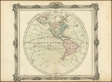
First state of De L'Isle's map of the Western Hemisphere, distinguishable from later states by the lack of any information regarding the Russian Discoveries after 1730. One of the earliest peninsular projections of California after Kino, in a configuration which became a standard for De L'Isle's and other maps. The odd little bit of Cap Blanc and an inlet west of Quivira foretells the mythical depictions of De Font and D'Aguilar. There is a hint of the old land bridge from Compagnie's Land to the NW Coast. The voyages of Vaisseau in 1710, Mendana, Gaetan, Magellan, Le Maire, Halley and Tasman through the Pacific are all depicted, as is the West Coast of New Zealand. No sign of the Antarctic, other than a note of a discvoery by Drake just above the polar circle. The Pacific is dotted with mythical islands. Some detail along the east coast of Australia. A nice example of the scarce first state of this map, bearing the date 15 Septembre 1724.
Guillaume De L'Isle (1675-1726) is probably the greatest figure in French cartography. Having learned geography from his father Claude, by the age of eight or nine he could draw maps to demonstrate ancient history. He studied mathematics and astronomy under Cassini, from whom he received a superb grounding in scientific cartography—the hallmark of his work. His first atlas was published in ca. 1700. In 1702 he was elected a member of the Academie Royale des Sciences and in 1718 he became Premier Geographe du Roi.
De L'Isle's work was important as marking a transition from the maps of the Dutch school, which were highly decorative and artistically-orientated, to a more scientific approach. He reduced the importance given to the decorative elements in maps, and emphasized the scientific base on which they were constructed. His maps of the newly explored parts of the world reflect the most up-to-date information available and did not contain fanciful detail in the absence of solid information. It can be fairly said that he was truly the father of the modern school of cartography at the commercial level.
De L’Isle also played a prominent part in the recalculation of latitude and longitude, based on the most recent celestial observations. His major contribution was in collating and incorporating this latitudinal and longitudinal information in his maps, setting a new standard of accuracy, quickly followed by many of his contemporaries. Guillaume De L’Isle’s work was widely copied by other mapmakers of the period, including Chatelain, Covens & Mortier, and Albrizzi.
![[ Pacific Ocean and America -- The West Indies ] Descripcion De Las Yndias Ocidentales](https://storage.googleapis.com/raremaps/img/small/95683.jpg)