The item illustrated and described below is sold, but we
have another example in stock. To view the example which
is currently being offered for sale, click the
"View Details" button below.
![[Republic of Texas] Map of Texas From the most recent authorities . . . 1845 By Henry Schenk Tanner](https://storage.googleapis.com/raremaps/img/small/43437.jpg)
1845 Henry Schenk Tanner
$ 1,400.00


|
||

|

|
|

|
Stock# 37744
Description
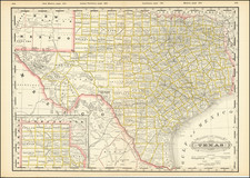
Fine example of Henry Schenk Tanner's map of the Republic of Texas, issued in Tanner's Universal Atlas.
The present example is the rare first state of Tanner's 1845 map of the Republic, pre-dating, the addition of a number of Texas Counties formed in 1845 and 1846.
The western part of the Republic is dominated by Bexar, Milam, Robertson and San Patricio Counties.
Fort Alamo is shown, along with a few dozen other place names. About 15 early roads are shown. Large inset shows Texas north of the Red River. A terrific map of the Republic, which was first issued in 1845, shortly before Tanner sold the rights to the Atlas to SA Mitchell.
![[California, Texas, and Southwest Globe Gore] with [Strait of Anian Globe Gore]](https://storage.googleapis.com/raremaps/img/small/99425.jpg)
![Map of the Missouri Pacific and St. Louis, Iron Mountain and Southern Railway and Connections [Missouri Pacific Railway. St. Louis & All Points East Chair Cars Free Fast Mail Route]](https://storage.googleapis.com/raremaps/img/small/91606.jpg)