|
||

|

|
|

|
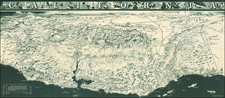
A highly decorative and large-scale plan of Moscow, depicting the city not long before the Revolution of 1917.
This magnificent map depicts all of Moscow and its environs as it appeared in 1910, during the twilight of the Czarist period. In large scale, the city unfolds with all of its 41 wards and the various parks distinguished by color, following the concentric pattern that was the hallmark of the city's development. The major edifices of the city: palaces, churches, government buildings, theaters and museums are expressed pictorially, while all major roads and landmarks are labeled. The elaborate network of railways connecting Moscow to the rest of the Russian Empire weave out of the city, including the western terminus of the Trans-Siberian Railroad. A detailed inset features a plan of the Kremlin. With its period Art Nouveau border, the map assumes an artistically virtuous appearance.
At the time that this map was issued, Moscow's economy was growing rapidly, and its population was around 1.5 million, having doubled in the previous 20 years. One of the most interesting features of the map is its demarcation of the city's tramline system. In 1872, the Compagnie générale des tramways de Moscou et de Russie, had introduced horse-drawn trams to the city. The network rapidly expanded, and from 1899 electric trams were progressively replacing the equestrian lines. The map distinguishes the various horse and electric systems.
Also prominent is the ring road (colored in bold red) that encircles the outskirts of the city. By this time the road, known as the 'Third Ring', had been proposed and construction had commenced, although the Revolution would place the project on hold. It was fitfully continued throughout the 20th Century, but was not fully completed until 2004.
This large map is exceptional in that it was intended to be both a fine work of art and a practical aid for navigating Moscow. It provides an unparalleled insight into the nature of Moscow shortly before Soviet planners redeveloped the city. While many key features still survive, the map is a primary artifact of an exciting and prosperous, yet bygone era.
The present map is very rare, we have never before encountered an example and have only been able to locate a single example in Russian state collections. The map would appear to have first been issued in 1907, as the date 1907 can be seen in the darker red area at the bottom right of the map. The rarity of the map may be accounted for by the fact that examples would have been hung up on the wall and subject to use and wear.
![[St. Petersburg] Kronstat From The Russian Survey . . .](https://storage.googleapis.com/raremaps/img/small/43365.jpg)