


|
||

|

|
|

|
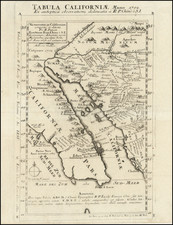
Fine example of Charles Drayton Gibbes important early map of the Gold Regions of California, engraved by Sherman & Smith.
Gibbe's map of the Gold Regions was one of most fascinating early maps of the Gold Region and is also of particular note as perhaps the earliest printed maps to identify County Boundaries in the state of California.
Gibbes' map was published within a year of California being admitted into the Union as a part of the Compromise of 1850. Gold production reached its peak in 1852, the year after the map was published. Many mining camps are pictured, including Toualamne City, Empire City, Jacksonville, Downingville, Coloma, Buck's and Illinoistown. Streeter (whose copy sold for $500 in 1968), noted as follows:
This map extending from 34 degrees 20 minutes n. to a little above 42 degrees is, because of its large scale and clear markings in colors of the different counties, one of the most satisfactory of the early California maps. It shows the state before Klamath County in the north, and Nevada and Placer Counties in the center, had been set apart and thus gives an earlier representation than the Butler map published the same year which shows these new counties. This map is before the discoveries on the Klamath River and, except for the Feather River and its tributaries, has few place names north of 39 degrees n. For the northern part of the state it follows closely the large scale Map of the United States ... between the Mississippi River and the Pacific Ocean. Compiled in the Bureau of the Corps of Topographical Engineers ... 1850. An important feature of the Gibbes map is that it is one of the first, if not the first, map of California to show county boundaries.
Wheat notes:
This interesting map shows Santa Cruz County as `Branciforte' and contains numerous place names in the mining region. `Toualumne' City, Crescent City and Empire City all appear along the Tuolumne River below `Jackson's.' `Downingvile' and `Goodhue's Bar' are shown on the Yuba, on either side of Rich Bar. The map extends only to Santa Barbara in the south.
Kurutz remarks that
Charles Gibbes came to California from Charleston, South Carolina, during the Gold Rush. In this supplement to his map, he included a description of California, its history, climate, soil, crops, bays, harbors, and rivers. He also provided pertinent information on the mines and advise for equipment. Putting the best face on the situation, he wrote: `Towns have sprung up at all the principal mining centres, and trading establishments in them furnish all needed supplies of provisions, clothing, tools, and other necessities, at reasonable rates.' Gibbes estimated that USD 100 million in gold had already been mined.
The map is rare on the market, this being the third example we have seen in the past 20 years.
![[ San Francisco and California Coast to Central Baja ] Cote Nord-Ouest De L'Amerique Reconnue par le Cape. Vancouver Ie. Partie . . .](https://storage.googleapis.com/raremaps/img/small/82224.jpg)