


|
||

|

|
|

|
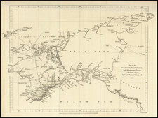
Extremely rare early map of St. Petersburg, issued only a dozen years after the city has been selected as Russia's new capital.
This fine plan shows St. Petersburg as it was planned to be built while it was still in the process of construction. In 1703, the site, at the head of the Gulf of Finland, was selected by Czar Peter the Great to be the place on which a new capital city for the Russian Empire was to be built. Peter pressed a massive labor force of serfs to build the city, and no expense was spared. Leading architects and artisans from across Europe were offered large salaries to dedicate themselves to the task. The overall project came to be overseen by the French landscape architect, Jean-Baptiste Alexandre Le Blonde, who had previously served Louis XIV, who was ably assisted by the Swiss architect Domenico Trezzini.
As shown on the main map, most of the city was planned to be built on Vasilyevsky Island, that lay within the mouth of the Neva River. As shown, the island was to be bisected by a series of canals and streets that were to follow a rational grid, which in places were to contain massive squares. On the south bank was the Admiralty district and on an island on the north bank, above Vasilyevsky Island, was the St. Peter & Paul Fortress. One might remark that much of the city resembles a series of gardens, and this is, in good part, due to the fact that Le Blonde's signature passion was designing gardens.
In spite of the massive resources thrown at the project, the original plan was greatly altered as work progressed. Vasilyevsky Island was proven to be too low-lying and prone to flooding to permit the creation of the canals, nor was it viewed appropriate as the site of the main town. While the area would eventually be built-up (later in the 18th Century) with streets largely following the lines of the proposed grid of canals, the main part of the city was built in the area which lay to the south of the Neva. Text running along the left side of the map identifies 28 different sites throughout the city.
In the upper right of the map is an inset 'Charte des Neva-Stroms', which shows the course of the River Neva, which flows from Lake Ladoga to the Gulf of Finland, and clearly depicts the location of St. Petersburg. Another inset, located on the right side of the map, contains a view of 'Cron Sloss', or Kronstadt, the fortified island in the Gulf of Finland that guarded the maritime approaches to the city.
The first printed map to depict a version of the Le Blonde-Trezzini plan was Nicolas De Fer's Plan de la Nouvelle Ville de Petersbourg (Paris, 1717). With some modifications, this was followed by Johann Baptist Homann's map of St. Petersburg, published circa 1720. The present map was printed in Frankfurt in 1724, and is derived from the Homann map, as it features the same cartographic detail, although the inset of the Neva is moved to upper right side of the map, from the upper left.
The present map is rare, we are not aware of another example appearing on the market as a stand-alone map during the last 25 years.