|
||

|

|
|

|
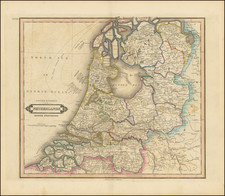
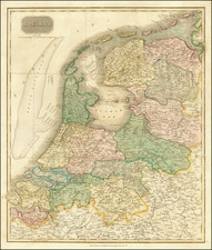
A rare and monumental wall map of the provinces of Holland and Utrecht, prepared by the Prussian engineer C.F. von Wiebeking, on the eve of the Napoleonic Wars.
This grand production covers the entire provinces of Holland and Utrecht, the heartland of the Dutch Republic. It was by far the most details and accurate general survey of the region made leading up into the Napoleonic Wars and represented a major achievement of Late Enlightenment cartography. It extends from the northern part of Zeeland in the south all the way north to embrace the Frisian Island of Schilling, and inlands eastwards into Gelderland. The topographical detail and precision is unprecedented, as all of the canals, dykes, river channels, roads, polders and towns are featured with great clarity. The map represented a phenomenal achievement, as the region was then the world's most complicated largely manmade landscape. The map was in its time considered to have been immensely valuable for military planning during this dramatic period in history, and was one of the finest works of the eminent engineer and cartographer, C.F. von Wiebeking.
Carl Friedrich von Wiebeking (1762-1842) was a German architect, water engineer and surveyor. For many decades, he was one of the leading figures in these fields throughout the German states and the Austrian Empire. He was born in 1762 into a noble family in Wollin, Pomerania, in the Kingdom of Prussia (today Wolin, Poland). A precocious talent, at only the age of 17, he was selected by the Prussian military leader and cartographer Lieutenant-General W.C.G. von Smettau to be his lead assistant during his project to survey the Duchy of Mecklenburg-Strelitz (1779). Under Smettau's patronage, Wiebeking later went on to conduct trigonometric surveys of large parts of west Prussia and Pomerania, as well as Saxony-Gotha, Saxony-Weimar and Mecklenburg-Schwerin, projects completed by 1786. Notably these were the most advanced surveys of these regions conducted at the time.
In 1788, Wiebeking moved to Düsseldorf to assume the relatively lucrative post of Chief Water Engineer for the Duchy of Berg, in the northern Rhineland. The region had suffered greatly due to chronic and severe flooding. Wiebeking worked closely with the engineer Johann Gottfired Tulla to successfully implement systems to contain the Rhine and its tributaries in order to protect the duchy's town and farms that lay along the rivers floodplains. In the process, Wiebeking completed an immense map of the Duchy of Berg, which remained by far the most accurate and detailed map of the region made for many years.
The present map of Holland was made by Wiebeking as an important side project during his assignment in Berg. In 1787, the Dutch Republic was invaded by the Prussian Army at the invitation of the ruling House of Orange, in an effort to suppress a rebellion of the liberal Patriots (later allied to the French Revolutionaries). While the Prussians duly handed the Netherlands back to the control of the House of Orange upon the defeat of the rebellion, Prussian influence endured for the next several years. As the Prussian campaign represented the first major land operation fought in the provinces of Holland and Utrecht since 1672, it quickly became clear that the existing printed topographical maps of the region were outdated and unfit for operational use. Following the beginning of the French Revolution in 1789, both the House of Orange and the Prussians had a prescient recognition that further military campaigns lay ahead.
It was in this context that Wiebeking was called upon to compile a map of Holland, based upon the most advanced available sources. While there were several highly competent surveyors resident in the Netherlands, it was regarded that none of them had his natural ability. Wiebeking was given special access to the finest military and civilian general surveys as well as cadastral maps housed in the Dutch archives, in addition to the maps commissioned by the various regional 'waterschappen' (water authorities), which regulated the canals and polders. Wieberking carefully analyzed all these sources to gain the most accurate picture. The present monumental work was published in Darmstadt, Hessen, in 1796.
Wiebeking's map was completed none-too-soon, as the Patriots (with French assistance) regained control of the Netherlands in 1795, naming it the Batavian Republic. Napoleon would go on to take control of the Netherlands outright in 1806. While the French engineers would make their own fine surveys of Holland and Utrecht, the present map served as the most accurate general overview of the region available to Allied (British, Austrian and Prussian) commanders who planned to invade the Netherlands. Indeed, British officials quickly recognized the importance of the Wiebeking's map when discussing strategy. On September 9, 1799, the British Foreign Secretary, Lord Grenville, wrote to the Marquess of Buckingham, "Have you got Weibeking's [sic] map of Holland and Utrecht? If not, let anybody write for it for you from Hamburgh." Grenville furthermore elaborated on various details of military significance as shown on the map [Marquess of Buckingham, Memoirs of the Court and Cabinets of George the Third: 1788-1799 (London, 1853), p.440]. The Allied powers mounted their first (unsuccessful) invasion of the Netherlands in 1809, and eventually succeeded in liberating the northern Dutch provinces from Napoleon's occupation in 1813.
From 1802 to 1805, Wieberking oversaw various engineering projects in the Austrian Empire, in locations ranging from Vienna to Trieste to what is now Croatia. In 1805, he moved to Munich to became Director General of Public Works of the Kingdom of Bavaria, a post he held until 1817. Several roads, bridges, and canals constructed under his supervision dot the Bavarian countryside to this day, and enduring testament to the quality of his work. In his retirement, Wiebeking served as an advisor to the Bavarian Minister, the Graf von Montgelas.
The present map represents a landmark in the mapping of the Netherlands and is a foremost artifact of Late Enlightenment cartography in Europe.
Carl Friedrich von Wiebeking (1762-1842) was a German architect, water engineer and surveyor. For many decades, he was one of the leading figures in these fields throughout the German states and the Austrian Empire.
He was born in 1762 into a noble family in Wollin, Pomerania, in the Kingdom of Prussia (today Wolin, Poland). A precocious talent, at only the age of 17, he was selected by the Prussian military leader and cartographer Lieutenant-General W.C.G. von Smettau to be his lead assistant during his project to survey the Duchy of Mecklenburg-Strelitz (1779). Under Smettau's patronage, Wiebeking later went on to conduct trigonometric surveys of large parts of west Prussia and Pomerania, as well as Saxony-Gotha, Saxony-Weimar and Mecklenburg-Schwerin, projects completed by 1786. Notably these were the most advanced surveys of these regions conducted at the time.
In 1788, Wiebeking moved to Düsseldorf to assume the position of Chief Water Engineer for the Duchy of Berg, in the northern Rhineland. The region had suffered greatly due to chronic and severe flooding. Wiebeking worked closely with the engineer Johann Gottfired Tulla to successfully implement systems to contain the Rhine and its tributaries in order to protect the duchy's town and farms that lay along the rivers floodplains. In the process, Wiebeking completed an immense map of the Duchy of Berg, which remained by far the most accurate and detailed map of the region made for many years.
From 1802 to 1805, Wieberking oversaw various engineering projects in the Austrian Empire, in locations ranging from Vienna to Trieste to what is now Croatia. In 1805, he moved to Munich to became Director General of Public Works of the Kingdom of Bavaria, a post he held until 1817. Several roads, bridges, and canals constructed under his supervision dot the Bavarian countryside to this day, and enduring testament to the quality of his work. In his retirement, Wiebeking served as an advisor to the Bavarian Minister, the Graf von Montgelas.
allow unhindered passage for the river boats and in order to be less vulnerable to drift ice and wood. The Bamberg Regnitz Bridge of 1809 was the largest wooden arch bridge of its time with a span of 72 meters.
Begining in 1807 Wiebking was a member of the Bavarian Academy of Sciences. Wiebeking maintained contacts with the Russian corps of traffic route engineers for more than thirty years.

![(France, Belgium, and Holland) Tabula Moderna Francie [Modern Map of France]](https://storage.googleapis.com/raremaps/img/small/101885.jpg)