|
||

|

|
|

|
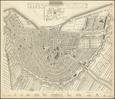
Lizars map of the Netherlands offers a detailed depiction of the region during a period of significant change, issued at about the same time as the Belgian Revolution.
The Kingdom of the Netherlands, during the early 19th century, underwent significant territorial and geopolitical transformations, marked by the ebb and flow of European power dynamics. This period encapsulates a critical era in Dutch history, characterized by the impact of Napoleonic wars, the Congress of Vienna, and the eventual Belgian Revolution. These events collectively shaped the modern boundaries and geopolitical stance of the Netherlands.
Initially, the Netherlands found itself under French influence at the turn of the 19th century, becoming a vassal state and later, part of the Napoleonic Empire. This annexation into France from 1810 to 1813 dramatically altered its international standing, drawing the country into the broader Napoleonic conflicts that ravaged Europe. The defeat of Napoleon at Waterloo in 1815 and the subsequent Congress of Vienna reshaped the European map, restoring sovereignty to many nations, including the Netherlands. The Congress of Vienna played a crucial role in redefining the Netherlands' boundaries and geopolitical status, leading to the creation of the United Kingdom of the Netherlands. This new political entity included the territories of the present-day Netherlands, Belgium, and Luxembourg, designed as a buffer state to counterbalance French power.
The period following the Congress of Vienna was marked by internal and external pressures that tested the cohesion of the United Kingdom of the Netherlands. The north and south, with their distinct languages, religions, and economic interests, found little common ground, leading to increasing tensions. These tensions culminated in the Belgian Revolution of 1830, a decisive event that reshaped the geopolitical landscape of the region. The southern provinces, predominantly Catholic and economically divergent from the Protestant, trade-oriented north, successfully seceded to form the independent Kingdom of Belgium after a protracted struggle recognized by the Dutch in 1839.
The aftermath of the Belgian secession significantly altered the Netherlands' strategic priorities and territorial boundaries. The separation consolidated the Netherlands' modern borders and compelled a reevaluation of its geopolitical strategies.The nation embarked on a path of economic modernization and neutrality, a policy that would define its international relations for decades to come.
The Lizars were a Scottish family of engravers and printers who produced many views and maps. Daniel Lizars Sr. (1754-1812) was the son of a shoemaker, but he apprenticed with Andrew Bell, a printer and engraver. Lizars set up his own printworks near St. Giles Cathedral and took on his own apprentices, including George Bartholomew, whose son John would go on to found the important mapmaking firm later know as John Bartholomew & Son Ltd.
Daniel Sr. had three sons: Daniel Jr., John, and William Home. He also had a daughter, Jane Home. Daniel Jr. (1793-1875), the youngest of the boys, apprenticed in his father’s shop alongside George Bartholomew. When his father died in 1812, Daniel Jr. took over much of the business, expanding it and specializing in maps. The company went bankrupt in 1832, however, and Daniel emigrated to Canada.
John Lizars (1792-1860), the middle son, studied medicine and became Professor of Surgery at the Royal College of Surgeons of Edinburgh, as well as senior surgeon at the Royal Infirmary of Edinburgh.
William Home Lizars (1788-1859), the eldest, also apprenticed in his father’s shop. After learning engraving, William entered the Trustees’ Academy to learn under John Graham. He was a skilled painter and artist. When his father died, and after his Daniel Jr. left, he carried on printing and invented a method of etching that looks like wood engraving.
![Sneecha. . . [and] Doccum. [and] Sloten [and] Ylstae](https://storage.googleapis.com/raremaps/img/small/89300.jpg)
![[ Holy Roman Empire, Poland, Baltic, etc. ] Germania VI Nova Tabula (First state!)](https://storage.googleapis.com/raremaps/img/small/94645.jpg)