
This item has been sold, but you can enter your email address to be notified if another example becomes available.


|
||

|

|
|

|
Stock# 36916
Description
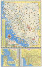
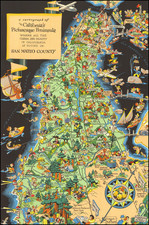
Fine pictorial map / view of the area around Palo Alto and Stanford University, published for the Palo Alto Chamber of Commerce.
The view is surrounded by illustrations of Stanford University Buildings, California Redwood Park, the Palo Alto Airport and other noteworthy buildings.
We have dated this map based upon the naming of Treasure Island, which suggests it was done at about the time of the Golden Gate International Exposition.
![[Alaska to San Diego and San Qunitin, British Columbia] A Chart Shewing Part of the Coast of N.W. America, with the Tracks of His Majesty's Sloop Discovery and Armed Tender Chatham . . . (First Modern Map of the West Coast of North America)](https://storage.googleapis.com/raremaps/img/small/102067.jpg)
![[Report and] Map of an Exploring Expedition to The Rocky Mountains in the Years 1842 and to Oregon & North California in the Years 1843-44 By Brevet Capt. J. C. Fremont of the Corps of Topographical Engineers . . .](https://storage.googleapis.com/raremaps/img/small/88488.jpg)