|
||

|

|
|

|
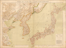
A very rare and fascinating map of Korea, printed by Russian intelligence operatives in Harbin, China, on the eve of World War I.
This truly curious map embraces the entire Korean Peninsula, and features all major towns, ports, roads, railways and provincial boundaries. All of the text is in Russian Cyrillic, and rivers and coastlines are colored through a rather crude form of lithography that lends a rather striking artistic effect to the map.
The map is the product of the vibrant contemporary Russian political and intellectual interest in the Far East. Russia had maintained a presence in Pacific Siberia since the 18th-century, but it was only in the late 1800s that their influence extended southwards. Following the Sino-Japanese War (1894-5), China's control of its frontier regions was weakened. Russia stepped in to virtually colonize large parts of Manchuria, and while not controlling any of its territory, maintained considerable influence over Korea, which was ruled by the declining Joseon Dynasty. In 1898, the Russians founded Harbin, Manchuria, which became a boomtown sustained by the Trans-Manchurian Railway (a spur of the Trans-Siberian Railway). It soon became the center of Russian financial operations and intellectual pursuits in East Asia.
In 1909, Colonel (later General) Nikolai Gerasimovich Volodchenko, a Russian Army officer, who served as head of the Trans-Amur Border Guards (Russia's frontier military police in the region) founded a branch of the Orientology Society ('Oshchestvo Vostokovedeniia') of St. Petersburg in Harbin. While the society would sponsor many worthy intellectual projects, its true purpose was to use the process of academic inquiry to obtain political and economic information that may be of value to the Russian state. In other words, it was a committee dedicated to 'enlightened espionage'.
Volodchenko was a larger than life figure who led several spy rings during his long service in the Far East. Recognized as an expert on methods of sabotage and reconnaissance, upon the outbreak of World War I (the year that the present map was published), Volodchenko was recalled to Europe to lead advance units of special forces. He was eventually promoted to serve as commander of the Southwestern Division of the Imperial Russian Army in the autumn of 1917.
Following her defeat in the Russo-Japanese War (1904-5), Russia's influence in Korea was curtailed. This situation became even more severe after Japan effectively annexed Korea in 1910. Partially as a scheme to gain intelligence, Volodchenko teamed up with V.N. Krylov, a scholar based in Harbin to produce A Dictionary of Japanese Geographical Names in Korea (published Harbin, 1914). This innocent-sounding publication was actually the product of a close study of the geography of Korea, which acted to update Russian knowledge of the peninsula. The present map was issued to accompany the book, and while not focused on toponomy of Japanese origin, it is a detailed and precise depiction of transportation infrastructure, rivers and major population centers, making it a useful map for military strategic purposes.
The map is exceedingly rare, we have not been able to find any record of other examples in institutional holdings, auction records or in dealers' catalogs, other than this example, which was recently purchased in the trade.
![[ Japan ] Royaume du Iapon. Designe par le Pere Ph. Briet de la Compagnie de Iesus . . .](https://storage.googleapis.com/raremaps/img/small/75238.jpg)