|
||

|

|
|

|
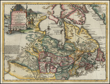
A scarce and highly detailed miniature map of Quebec City, made following the conquest of the city during the Battle of the Plains of Abraham (1759).
This finely-engraved map depicts the City of Quebec and immediate environs as it appeared during the Seven Years' War (or the French & Indian War). Founded in 1608, Quebec had been the capital of New France. As shown, it sat atop the great precipice of Cape Diamond, imposingly guarding the St. Lawrence River. The map shows the elaborate fortifications that surrouded the city, while the 'Renvois', or key, identifies 27 major buildings and sites, including churches, government buildings and military infrastructure. While the map is of a modest size, the quality of the engraving and detial of the presentation provides a surprisingly thorough overview.
While the town was considered to have a defensively impenetrable position, a daring operation launched by British General James Wolfe succeeded in capturing the city in September, 1759. Some of the action of the siege is pictographically expressed on the map, including canon vollies from the British ships in the river. As noted in the inscription to the right of the 'Renvois', the city, along with all of French North America, was formally ceded to the British by the Treaty of Paris (1763).
This map was issued by Beaurain in 1765, both to serve as one of the border illustations added to his great wall map recording the events of the Seven Years' War, the Carte de Allemagne... (1765), and, as is the case here, as a separately-issued map, mounted on larger piece of paper and bound into a made-to-order atlas.

![[ Queen Anne's War - Failed Attack on French Canada -- Petition to Queen Anne from the Colony of New York seeking reimbursement for a failed conquest of New France during Queen Anne's War ] To the Queens most Excellent Majesty . . . 1709](https://storage.googleapis.com/raremaps/img/small/85409.jpg)