
The item illustrated and described below is sold, but we
have another example in stock. To view the example which
is currently being offered for sale, click the
"View Details" button below.


|
||

|

|
|

|
Stock# 3662
Description
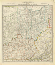
Marvelous regional map, showing the early counties, towns, roads and Indian details.
Interesting annotations in Indiana and a large reserve for the Miamis and Potowatomies. The counties in Ohio, Kentucky and Viriginia are still not completely formed. Based in part of information derived from Henry Schenk Tanner, who receives credit in the lower left corner of the map. Information key notes abbreviations for Bridges, Court Houses, Churches, Creeks, Forks, Lakes, Post Offices, Springs, Villages, Indian Villages, Forts, etc.


![(Fools Cap) Afbeeldinge van't zeer vermaarde Eiland Geks-Kop [Picture of the Highly Renowned Island of Fools Cap, Situated in the Sea of Shares, Discovered by Mr. Lau-rens.]](https://storage.googleapis.com/raremaps/img/small/104266.jpg)