|
||

|

|
|

|
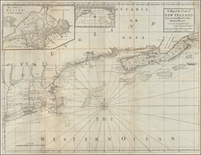
A very fine example of the First State of Jefferys' map of the siege of Quebec of 1759, widely considered to be the most important single printed military map in Canadian history.
This fascinating map embraces the environs of Quebec City and was one of the first maps to be printed in London following news of the British victory on the Plains of Abraham in 1759, the fateful showdown between the armies of General James Wolfe and the Marquis de Montcalm. It shows the city and topography in carefully rendered detail. All of the main scenes of action surrounding the British siege are shown, including the abortive attack on Beauport, the British Headquarters at Levis and the site of the decisive Battle of the Plains of Abraham. Interestingly, each vessel of the British fleet, under the overall command of Admiral Saunders, appears in pictographic form, with the names of each ship labeled. The map was considered to be by far the most authoritative geographical depiction of this momentous series of events and was used as the source map for many other publications printed in London.
To lend perspective, the map includes a detail inset of the decisive battle itself, A view of the action gained by the English Sepr. 13, 1759 near Quebec, brought from thence by an officer of distinction and another inset map entitled Part of the upper river of St. Laurence, showing the region located upriver of that depicted on the main map.
Thomas Jefferys (1719-1771) was the leading British cartographer of his era, and is credited with spearheading London's ascendency as the world's premier map center during the second half of the 18th-century. He was the official cartographer to George III and is best known for his publication of many of the most important maps of the Seven Years War (or the French & Indian War) as well as a groundbreaking series of surveys of American colonies.
Jefferys map of Quebec is rarely seen in the present first state.
Thomas Jefferys (ca. 1719-1771) was a prolific map publisher, engraver, and cartographer based in London. His father was a cutler, but Jefferys was apprenticed to Emanuel Bowen, a prominent mapmaker and engraver. He was made free of the Merchant Taylors’ Company in 1744, although two earlier maps bearing his name have been identified.
Jefferys had several collaborators and partners throughout his career. His first atlas, The Small English Atlas, was published with Thomas Kitchin in 1748-9. Later, he worked with Robert Sayer on A General Topography of North America (1768); Sayer also published posthumous collections with Jefferys' contributions including The American Atlas, The North-American Pilot, and The West-India Atlas.
Jefferys was the Geographer to Frederick Prince of Wales and, from 1760, to King George III. Thanks especially to opportunities offered by the Seven Years' War, he is best known today for his maps of North America, and for his central place in the map trade—he not only sold maps commercially, but also imported the latest materials and had ties to several government bodies for whom he produced materials.
Upon his death in 1771, his workshop passed to his partner, William Faden, and his son, Thomas Jr. However, Jefferys had gone bankrupt in 1766 and some of his plates were bought by Robert Sayer (see above). Sayer, who had partnered in the past with Philip Overton (d. 1751), specialized in (re)publishing maps. In 1770, he partnered with John Bennett and many Jefferys maps were republished by the duo.