|
||

|

|
|

|
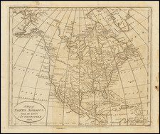
Early post-Lewis & Clark Depiction of the Transmississippi West.
Fine map of North America, recently updated to show course of the Rivers traversed by Lewis & Clark, including the Upper Missouri, Yellowstone, South Fork, Lewis River, Clarke River, etc. This edition is significantly revised from the 1808 edition, based on the recently published account of Lewis & Clark's expedition, first published in Philadelphia in 1814.
Alaska is labeled Russian Settlements and has a marvelous conjectural coastline north and east of Cape Mulgrave. The Pacific Northwest is identified as Vancouver's Surveys and shows nice detail, albeit limited to the coastline.
To the North, the better information furnished by the Hudson's Bay company is in evidence. In the Southwest, the many tributaries of the Colorado River are pure fiction and the Gila River is missing. The Missions of Upper California are shown, along with some mythical lakes and rivers.
The map is apparently much revised from Wilkinson's map of 1794 and Wilkinson's map of 1808, described by Wheat.
An excellent post-Lewis & Clark map.