The item illustrated and described below is sold, but we
have another example in stock. To view the example which
is currently being offered for sale, click the
"View Details" button below.


|
||

|

|
|

|
Stock# 34579
Description
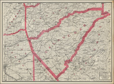
Highly detailed pocket map of Calaveras County, published by C.F. Weber.
The map shows early railroads, roads, wagon roads, mines, lakes, mills, and many other details.
Calaveras County was one of the original counties of the state of California, created in 1850 at the time of admission to the Union. Parts of the county's territory were reassigned to Amador County in 1854 and to Alpine County in 1864.
Condition Description
Pocket map with printed covers.