This item has been sold, but you can enter your email address to be notified if another example becomes available.


|
||

|

|
|

|
Stock# 34558
Description
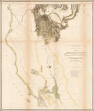
Fine example of this early pair of maps showing details of the mining regions in California, which accompanied Mason's Report on the Diggings. In President Polk's Message to Congress, December 5, 1848.
The maps are based upon Mason's observations in July 1848, shortly after the discovery of Gold in California on the South Fork of the American River.
The map locates the Saw Mill constructed by Marshall which led to the gold discovery, as well as the location of Wright's Store, Marshall's property and the local roads and location of the gold discoveries. From these humble beginnings, the biggest Gold Rush in American history was launched in 1849.
Reference
Wheat, C.I. (Gold) #52.

![(California Gold Rush) Oregon and California in 1848 in Two Volumes [with:] Map of California, Oregon, Texas, and the Territories adjoining with Routes &c.](https://storage.googleapis.com/raremaps/img/small/82901.jpg)
![Tunison's California, Oregon and Nevada [Yosemite Valley & Big Trees Vignettes]](https://storage.googleapis.com/raremaps/img/small/92845.jpg)