


|
||

|

|
|

|
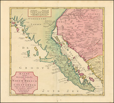
One of the best mid 18th Century maps of California, Baja California and parts of Arizona and Mexico.
Extends North to show the Channel Islands and Pt Concepcion, San Pedro and San Diego. Extends north along the Colorado and east along the Gila to include Casa Grande andthe Phoenix and Tuscon areas. The Missions in Arizona and Baja California are noted and in some cases, the founding date shown. One of the best mid 18th Century maps for California and Baja Collectors and certainly the most ambitious commercial effort to map the region.
An essential map for Baja, Arizona and Southern California collectors.
Isaak Tirion was a prominent Dutch publisher based in Amsterdam in the eighteenth century. He is best known for historical works that included prints showing scenes from around the world. He also produced maps, such as those in the Nieuwe Hand-Atlas of 1744.
![[Mexico and Central America with Baja California inset, from Generalkarte von Nord America samt den Westindischen Inseln Versasst von Herrn. Pownall . . . MDCCLXXXVIII]](https://storage.googleapis.com/raremaps/img/small/95064.jpg)
![Chart of the Coast of California from San Blas to San Francisco Drawn chiefly from the Spanish Surveys, the Charts of Vancouver &c. the whole much improved by recent observations made by English and French Naval Officers . . . 1854 [Additions to 1862]](https://storage.googleapis.com/raremaps/img/small/58999.jpg)