|
||

|

|
|

|
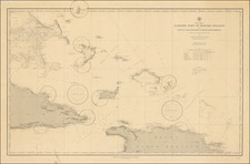
Rare pamphlet of sailing instructions and two charts for the Providence Channel and the Bahama Bank, published in Paris in 1825.
The first chart extends from the east coast of Florida to the Grand Albaco Island, with the second chart depicting the passage between the North coast of Cuba a Key West, what used to be know as the Old Bahama Channel. Both charts contains information on wind direction, currents, magnetic variation, soundings, and shoals; together with the tracks of the sailing routes outline within the text.
It is clear from the text that the directions and the charts were a product of Steetz's own surveys. He is rather dismissive of the majority of previous surveying of the area, and blames the errors upon the charts of Edmund Blunt - one of the leading American chart publishers - for causing numerous accidents. He does, however, reserve praise for Mr De Mayne a Royal Navy Surveyor, who spent several years in the West Indies, and whose charts Steetz drew from extensively.
The tracks outlined in his work were highly regarded and would continue to be marked upon Depot de la Marine charts for the next thirty years. Alexander Von Houmbolt on page 88 of his work, 'Personal narrative of travels to the equinoctial regions of the New Continent..' 1829, references "Captain Steetz['s]... excellent maps that accompany l'Instruction nautique sur les Passages à l'île de Cuba, 1825, p. 55".
Little is known about William Steetz, even though, as the title states, he was awarded the Legion of Honour. It is possible - although unlikely - that he was American, as his name appears as a member of the Washington Lodge No. 21,F. & A.M. (Masons) in 1815 (New York City).
![County Map of Florida [with Maps of North & South Carolina and inset of Charleston]](https://storage.googleapis.com/raremaps/img/small/92536.jpg)