


|
||

|

|
|

|
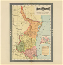
The Rare Deseret Edition of Tanner's Map of Mexico.
Exceedingly rare 1850 edition of Tanner's map of Mexico, one of the most important maps in 19th Century American History.
The present example, which is significantly revised from the 1847 edition, would appear to be the first map to name and identify the proposed State of Deseret and the first to name Salt Lake City.
Tanner's map of Mexico is without question one of the most important maps of the Western United States. From its early editions in 1825 and 1826, which were an integral part of shaping the US Boundary with Mexico, to the later editions, which show the Gold Regions and the proposed State of Deseret, the evolution of Tanner's map graphically depicts on a single canvas, the evolution of the West from 1825 to 1850.
This 1850 edition includes for the first time two of the most important Western events of the mid-19th Century. First, the 1848 discovery of Gold in California and the subsequent 1849 Gold Rush are marked brightly in yellow, with the words "Gold Region" added to the map. The map is revised to include significantly more topographical detail in the Gold regions. To the east of the Sierra's the Watershed of the Eastern Slope of the Sierras has been added and two new mountain ranges and the Humboldt River now appear in what would become Nevada. Nueva Helvetia is removed and many new place names have been added the Gold Regions and adjoining parts of California and Nevada.
Second, farther to the East, there are also significant changes in what would become Utah Territory in September 1850. The name Deseret is added and an area of the map is shaded in Yellow, showing what would appeare to be recognition by the publisher of the proposal sent by Brigham Young to Washington to create the State of Deseret (1849), and the formal organization of a shadow government for the future state of Deseret in 1850. The name Salt Lake City is also added for the first time and may in fact be the earliest appearance of this name on a printed map.
Other additions in the Salt Lake area include the change of the name Sevier Lake (1847 edition) to Nicolet Lake, Fort Bridger appears for the first time on the map, and the White River and Yampa River are added south of the Green River and Fremont's Route. A Lake has also been added south of the Virgin River. A Lake and River system also appear to the west of the Wasatch Mountains below Lake Nicolet, to the north of Vegas de Santa Clara, one of the major points on the Old Spanish Trail, which is illustrated on the map.
Brigham Young's State of Deseret
The provisional State of Deseret was founded in 1849 by Latter-Day Saint settlers in the Salt Lake city area. Brigham Young sent John Milton Bernhisel to Washington, D.C., to petition for territorial status, but later, in March 1849, elected to change the petition to a request for Statehood. The proposed state covered most of the lands from the Rocky Mountains and Oregon Territory to Mexico, extending west to the Sierra Nevadas and south to the Santa Monica Mountains, including Los Angeles and San Diego. While the provisional government met for several years, Utah Territory was formally created in 1851.
The present map is one of only two maps of which we are aware to include the name Deseret in 1850 (the other being a German map by Joseph Meyer). We also note several maps published in 1850 to include Salt Lake City, all but one of which show Utah Territory and therefore would almost certainly post-date this map. The only other map we located which pre-dates the inclusion of Utah Territory was the second 1850 edition of Thomas Cowperthwait & Company's map of Oregon & Upper California. As this map was issued later in 1850, it is unlikely that the map pre-dates the Tanner.
Overview of the Various Editions of the Tanner Map
The first edition, first state of Tanner's map (dated 1825, but released in 1826), was the only edition of the map to properly illustrates the boundary between the United States and Mexico. In the second state (dated 1826), the boundary is erroneously moved to the north in what is then shown as New Mexico. It is this erroneous boundary line between the two countries which is copied first by White Gallaher & White in 1828 (Mapa de los Estados Unidos de Méjico . . .).
Thereafter, in 1846, John Disturnell acquired the White Gallaher & White plate and re-issued the map in 1846 and 1847 without changes to the boundary line. As a result of this error, the 1826 Tanner / 1828 White Gallaher & White / 1847 Disturnell boundary becomes the official boundary between the United States and Mexico, until the error was discovered by the Boundary Survey Commissioners, which in turn necessitated, among other factors, the 1853 Gadsden Purchase.
Wheat noted that in the first edition of the map "the southern boundary of New Mexico seems to follow Humboldt, but in 1826 Tanner alterd that boundary west of El Paso, to bring it further north." It was this 1826 issue of the map which became the source for the White Gallaher and White map of 1828, which in turn became the source for Disturnell's celebrated "Mapa de los Estados Unidos de Mejico, first published in 1846," creating the erroneous boundary in the Treaty of Guadalupe Hidalgo.
Tanner based his 1825 map on the work of Alexander von Humboldt, Don Juan Pedro Walker, Zebulon M. Pike, William Darby, Bernardo de Orta, J.F. de Lángara y Huarte, and other sources. Tanner's map became the source for many future mapmakers.
In subsequent additions, a number of important updates were made, including information derived from John Fremont, and later information from official sources regarding the Gold Regions and the area around Salt Lake which were included in this 1850 edition of the map.
Tanner's maps of Mexico were a primary source on Mexico and the emerging western territories of the United States for three decades. For instance, Tanner's 1834 map was one of the few sources to include Stephen F. Austin's maps and (Tanner also published Austin's maps). As Wheat notes, the map was probably rushed into production to take advantage of the great interest in news of the Mexican-American War.
This 1850 edition is very rare. This is one of only a few examples to appear at auction in the past half century.
![[ Gulf Coast & West Coast of Florida ] De Cust van Westindien Van La Desconoscida, tot C. Escondido. . .](https://storage.googleapis.com/raremaps/img/small/65741.jpg)
![[Republic of Texas] Map of Texas From the most recent authorities . . . 1845](https://storage.googleapis.com/raremaps/img/small/43437.jpg)
![[ Lake County Rancho ] Map of the Guenoc County Rancho Finally Confirmed To A.A. Ritchie & P.S. Forbes, Surveyed under the Direction of the U.S. Surveyor General By Wm. Denton Deputy Surveyor. June 1857.](https://storage.googleapis.com/raremaps/img/small/102630.jpg)