|
||

|

|
|

|
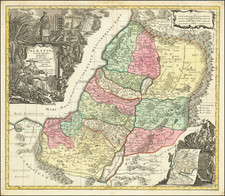
First edition of Nolin's 4-sheet map of the Holy Land, first published in Paris in 1700, credited to information provided by Paul de Miglionico, who spent 30 years in the Holy Land
Nolin's wall-map of the Holy Land is an entirely new production, presented with an elaborate title cartouche set on a larger drapeau, filled with historical and geographical descriptions and table of place names and descriptions, outer borders inset with 18 plans and views of the Holy site, inset scale bars, advertisement and table chronologique.
Nolin's wall map of the Holy Land is a striking and unique production, and must be seen as one of Nolin's finest maps. By the end of the 17th Century, Nolin was recognized as one of Europe's most prominent cartographers, especially following his very successful collaboration with Coronelli during the latter's time in Paris. Nolin's map of the Holy Land demonstrates a combination of fine engraving and aethetic decoration, combined with a superb geographical rendering of the region.
The map provides a fine compilation of historical events and places as reported by the Bible, with north at the top, a convention which had not yet become standardized on Holy Land maps as of the date of publication. Extending from the Nile Delta to Lebanon, it depicts the lands of the Twelve Tribes of Israel and features information from the Old and New Testaments, the History of Josephus Flavius and the accounts of Paul de Miglionico.
On either side of the map, a set of carte-a-figure style panels includes on the left, a set of six views of Biblical towns, along with two plans of buildings, including two of Jerusalem, one showing the city at the time of Christ, and the other in its modern form. On the right are eight views and plans of important holy sights
Among the most interesting textual features is a year by year description of the forty year wandering of Moses and the Israelites from Egypt to the Holy Land.
The map is quite scarce on the market, with no examples reported in AMPR in the past 30 years. We note that a late edition, published by Janvier in 1770, was offered for sale at Christies in London on April 27, 1994 (Sale 5129, Lot 203, sold for 4,370 GBP, including premium).
Jean-Baptiste Nolin (ca. 1657-1708) was a French engraver who worked at the turn of the eighteenth century. Initially trained by Francois de Poilly, his artistic skills caught the eye of Vincenzo Coronelli when the latter was working in France. Coronelli encouraged the young Nolin to engrave his own maps, which he began to do.
Whereas Nolin was a skilled engraver, he was not an original geographer. He also had a flair for business, adopting monikers like the Geographer to the Duke of Orelans and Engerver to King XIV. He, like many of his contemporaries, borrowed liberally from existing maps. In Nolin’s case, he depended especially on the works of Coronelli and Jean-Nicholas de Tralage, the Sieur de Tillemon. This practice eventually caught Nolin in one of the largest geography scandals of the eighteenth century.
In 1700, Nolin published a large world map which was seen by Claude Delisle, father of the premier mapmaker of his age, Guillaume Delisle. Claude recognized Nolin’s map as being based in part on his son’s work. Guillaume had been working on a manuscript globe for Louis Boucherat, the chancellor of France, with exclusive information about the shape of California and the mouth of the Mississippi River. This information was printed on Nolin’s map. The court ruled in the Delisles’ favor after six years. Nolin had to stop producing that map, but he continued to make others.
Calling Nolin a plagiarist is unfair, as he was engaged in a practice that practically every geographer adopted at the time. Sources were few and copyright laws weak or nonexistent. Nolin’s maps are engraved with considerable skill and are aesthetically engaging.
Nolin’s son, also Jean-Baptiste (1686-1762), continued his father’s business.
![[ Cyprus, Syria, Palestine, etc. ]](https://storage.googleapis.com/raremaps/img/small/103027.jpg)
![(Israel) Tabula Moderna Terre Sancte [Modern Map of the Holy Land]](https://storage.googleapis.com/raremaps/img/small/101884.jpg)
![[Exodus from Egypt] Haec Chorographia indicatur iter quod ab exitu Aegypti populus Israelius . . .](https://storage.googleapis.com/raremaps/img/small/87508.jpg)