|
||

|

|
|

|
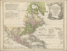
Rare 2-sheet map of North America, published by William Berry in London in 1681.
William Berry and Robert Morden petitioned the King of England for a license to publish maps for a world atlas in 1678. By 1680, William Berry, then working alone, had completed a 2-sheet map of the World. The present map also bears the date of 1680 in the scale of miles, but was almost certainly not completed until 1681, as it includes a references to Pennsylvania, which was not granted its charter until March 4, 1681. As such, it may in fact pre-date Thornton & Seller's A Map of Some ofthe South and eastbounds of Pennsylvania in America . . . , which is generally regarded as the first printed map to name Pennsylvania, which was not printed until the Summer of 1681.
Burden notes that as a prominent mapmaker, Berry "would have undoubtedly been approached [by William Penn], especially if given the opportunity to influence the outcome of a late yet to be finished." Curiously the name Pennsylvania does not appear in the title at the top (which names many other colonies), there is no engraved boundary line between Pennsylvania and New York and there is evidence of erasures on the plate. As such, all indications are that it was a last minute addition to a plate that was begun in 1680, but likley not completed until 1861. All of the above suggests that the map was released by Berry very shortly after Penn's establishment of the colony.
The map is largely based upon Alexis Hubert Jaillot's map of 1674, although the names have been significantly anglicized and ther are other additions and corrections. Burden also suggests that this fine map could have been engraved be Herman Moll, making it among the earliest examples of his work. The map includes a very large representation of California as and Island and a bold depiction of the Straits of Anian.
William Berry's atlas is very rare. Burden notes the existence of only a few examples, making the present map a remarkable survival.
![(Early California Trade) [Royal Decree of October 22,1803, to encourage trade in California]. D. Joseph de Yturrigaray, Caballero profeso de la Orden de Santiago, Teniente General de los Reales Exércitos, Virrey, Gobernador...Con fecha de 22 de Octubre del año proximo anterior...la Real Orden...Con objeto de fomentar la Agricultura y Comercio de las Californias, se ha servido el Rey habilitar sus Puertos en calidad de menores...](https://storage.googleapis.com/raremaps/img/small/93851.jpg)