|
||

|

|
|

|
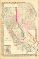
Railroads and Canals -- Mapping The Owens Valley in the 1880s
Meticulously drawn map of the area east of the Sierra Nevada Mountains, from just north of Bishop to the Tehachapi Pass, drawn on February 4, 1889 by L.F.J. Wrinkle.
The primary purpose of the map was to illustrate a proposed extension of the Carson & Colorado Railroad "from Keeler to Mohave." The completion of this line would have linked the Carson & Colorado with the Southern Pacific Railroad, then only the second transcontinental railroad, via the Texas and Pacific Railroad. Of equal or perhaps greater interest is the "proposed high level canal", running along the eastern slope of the Sierra Nevada Mountains. While likely never constructed, the proposed canal foreshadows the future location of the Los Angeles Aqueduct, an important chapter in the development of Los Angeles which would begin with the acquisition of land in the Owens Valley two decades later.
The map was compiled by L.F.J. Wrinkle, an M.I.T. graduate, who went to Virginia City as a surveyor. After serving as commissioner of the United States Land Office and superintendent for the Inyo Development Company, Wrinkle became a professor of engineering at the mining school at the University of Nevada Reno.
Oriented with west at the top, the map begins at the junction of the Southern Pacific Railroad and the Atchison, Topeka and Santa Fe Railroad at Mojave, California, at the point where the Southern Pacific completes its course northward through the Tehachapi Pass. The map the tracks the course of the proposed railroad line through the Antelope Vlley, noting in survey details, including two reservoir sites on either side of Little Lake, south of Owens Lake.
Of significant interest, the map also notes a "Proposed High Level Canal," which would have channeled water from the Owens River, beginning just east of Big Pine and flowing above Alabama Hills and Lone Pine, bypassing Owens Lake to the west, and ending with what appears to be an existing channel at Haiwee, which in turn connected the two proposed reservoir sitesaand Little Lake. This canal is a remarkable precursor to the Los Angeles Aqueduct. Our research notes discussions of prospective canals in this area in order to supply the Indian Wells Valley south of Little Lake as early as the 1893. We also note a fascinating article in the Los Angeles Herald dated June 21, 1891, where Charles Mulholland, identified as the editor of the Inyo Independent, gives an account of the prospects of the Owens Valley, where is describes in detail a number of Canal projects.
The map also notes an "East Side Canal", which channeled Owens River water southward from north of Independence to Owens, Lake, likely a primary channel for agricultural water which fed valley farmers in the 1880s.
The map identifies a number of the small Owens Valley communities then in existence, including Laws, Bishop, Alvord, Big Pine, Fish Springs, Elna, Tibbets, Independence, Lone Pine, Swansea, Keeler, Olancha, and Haiwae, most of which were on the proposed rail line. Major topographical features are also shown, including the major lakes and Creeks in the this part of the Eastern Sierra Nevada Mountains.
The Carson and Colorado Railway
Incorporated on May 10, 1880, the Carson and Colorado Railway was a 3 ft narrow gauge railroad that ran a 300-mile route from Mound House, Nevada, to Keeler, California. Construction commenced on May 31, 1880, shortly after its incorporation. Originally conceived as a means of moving rich mineral deposits of Western Nevada. As early as April 9, 1881, the Virginia City Evening Chronicle noted an intent to extend the line through the Owens Valley to Keeler and on to Mojave, where it could intersect with the lines of the Southern Pacific Railroad and the AT&SF, servicing the Mining Districts of Inyo Mountains east of Owens Lake, the soda and potash deposits at Owens Lake, agricultural interests in the Owens Valley and ultimately, to link up with the southern lines near Mojve. At the time, the Cerro Gordo mines were producing lead, silver and zinc, which was transported by steamer across Owens Lake and then south by Wagon to Mojave and Los Angeles.
The first train arrived at its southern terminus in Keeler on August 1, 1883. As noted by John Due,
As soon as the Carson and Colorado reached Keeler, plans were made to extend it to Mojave, 120 miles to the south, in order to connect with the Southern Pacific. Surveys were made; the Railway Gazette carried several notations during the middle eighties that the road would be continued south in the near future. But construction was never actually started; the relative unprofitability of the road after 1883, the decline of mining in the area, and the lack of interest in the road by [Darius] Mills, the chief source of capital, resulted in failure to undertake the extension. After Mills had completed his first trip over the line in 1883, he is quoted as having said to his associates that they had either built this line 300 miles too long, or 300 years too soon.
Despite its utility in serving the mining industry and the wider region, by 1892, the line was restructured and a in 1900, the railway was sold to the Southern Pacific Company. Until this point, it had been a subsidiary of the Virginia and Truckee Railroad (V&T), which had its own economic considerations and viewed the Carson and Colorado as more of a liability than an asset. After the acquisition, the Southern Pacific began to introduce changes, including starting the process of converting a portion of the line to standard gauge in 1905. The line existed until 1960.
![[Monterey] Plan De La Baie De Monterey Situee Dans La Californie Septentrionale . . .](https://storage.googleapis.com/raremaps/img/small/99008.jpg)