


|
||

|

|
|

|
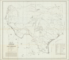
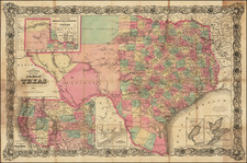
First edition of this remarkable separately issued map of Texas and part of New Mexico, prepared by the the United States Topographical Engineers in 1857 and issued in very small numbers, likely only for use by the Army.
The map provides a detailed overview of the region immediately prior to the Civil War, including perhaps the most detailed treatment of the railroads (existing and proposed) and road system in the region, along with a detailed treatment of the rivers, lakes, springs, creeks, crossings, water holes, Indian trails, pioneer routes, towns, camps, forts, ranches and other features of strategic military importance.
This map has been referred to as "the finest military map of Texas and parts of New Mexico printed prior to the Civil War," and "a monumental cartographic acheivement," incorporating the best available information from over a dozen other contemporary government surveys and brought together here in a single fine large format presentation.
The table at the bottomr right of the map also identifies the 30 major military stations in the region, including in most instances the coordinates and commanding officers, along with a list of approximately 15 maps and surveys which were incorporated into the map.
In describing his copy of the first edition of the map, Rumsey noted:
Probably the best and most detailed military map of Texas issued before the Civil War - rivers, roads, explorer's routes, water holes, forts and towns are shown. Includes "List of authorities." The Warren map of 1857 . . . incorporates much of this information, with even more information from this map appearing on the Warren map of 1858. A later version of this map appeared in the Atlas To Accompany The Official Records of the Union and Confederate Armies . . . as plate 54. Martin and Martin incorrectly state that the map was not published until it appeared in the "Atlas to Accompany. . . . .". This is the only government map published by H.F. Walling that we know of.
The map is one of several regional maps of the Western United States prepared at by the Bureau of Topographical Engineers prior to the Civil War, but which are now virtually unobtainable. Given its rarity on the market, it must be surmised that it was issued for use only by senior military officials and was circulated in very limited numbers.
The map is of the utmost rarity and only a few copies have been offered for sale in the past 50 years. As noted by Rumsey, the authors of Martin & Martin were unaware of the existence of the original edition and instead reference a reduced edition published in 1880.
![[Early Texas Aeronautical Navigation Map] Aeronautical Map For Cross Country . . Drawn by Cpl. V.G. Smylie Aero Squadron, Ellington Field](https://storage.googleapis.com/raremaps/img/small/59678.jpg)
![[Matagorda Bay] Bahia De S. Bernardo](https://storage.googleapis.com/raremaps/img/small/54374.jpg)