|
||

|

|
|

|
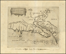
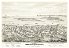
Important early map of Sausalito, showing the lands of the Sausalito Land & Ferry Company, printed by G.T. Brown & Co. in San Francisco.
The map would appear to be the earliest printed map of Sausalito and is pre-dated in OCLC only by a photocopy of the G.F. Emmons manuscript map of the town, produced circa 1851.
Oriented with Southwest at the top, the map provides an excellent look at the detailed planning associated with the re-birth of Saucelito in 1868. The town is meticulously laid out over a fine topographical presentation of the terrain adjoining Richardson's Bay and extending to Bear Valley and Tennessee Valley. A number of the waterfront blocks laid out on the map were actually underwater at the time of its construction, as highlighted by the meandering coastline adjoining Richardson's Bay. This ambitious use of the waterfront did not result in permanent streets or development for a significant portion of the underwater lands, but some parts of this original layout did in fact survive in the present layout of the town.
The map is of the utmost rarity. We were able to locate only 3 examples (Bancroft, British Library and Huntington Library). Brown produced another map of Sausalito in 1875 (1 copy located - Bancroft). No other maps of Sausalito were apparently published until 1880, when the Schmidt Label Company published a a new map for the Sausalito Land and Ferry Company (1 copy located at Yale).
The Saucelito Land & Ferry Company was the driving force behind the second boom in Saucelito. By 1853, the initial boom had busted and many of the stores and mills in Saucelito were torn down or otherwise destroyed. In 1868, the Saucelito Land & Ferry Company purchased a tract of land and began advertising water front property in Saucelito Ranch in 1868. According to advertisements in contemporary news accounts, the company owned 1,160 acres of land and constructed a new wharf, from which it proposed to operate the Ferry Boat Princess, which would run from Meigg's Wharf in San Francisco. The company also advertised that it was "donating a large sum of money" to the San Francisco and Humboldt Bay Railroad Company, to commence grading of a line from the company land in Saucelito to San Rafael.
The company proudly advertised that it had retained Col. Charles Seymour Bulkley, who had recently completed servicing as Chief Engineer on the Russian American Telegraph Expedition, to serve as surveyor and planner for the company lands. Charles Seymour Bulkley was born in Virginia in 1840. He invented the Bulkley Telegraph Repeater and equipment for paying out underwater telegraph cable. Bulkley is perhaps best known as the Engineer-in-charge of the survey team of the Collins Overland Telegraph Company who, in 1866 explored the area around the Bulkley River, a major tributary of the Skeena River in British Columbia, in preparation for the failed Russian-American Telegraph. The Bulkley Valley is also named for Bulkley. After the failure of this venture, Bulkley relocated to the San Francisco area, and was later in White Pine, Nevada, likely to capitalize on the ongoing mining boom in the region.
Bulkley laid out the town in a series of town lots and larger country seats, along with the streets shown on the map. The first building constructed was the Saucelito Hotel in 1869. A second hotel was built near the Ferry Landing in 1969, but burned in December 1879. In 1870, a store was constructed just south of the Ferry Landing, the same year in which the post office was established.
The map credits G.T. Brown as the printer (and W. Vallance Gray as the lithographer), making this one of the earliest maps produced by G.T. Brown & Company. Grafton Tyler Brown is perhaps the first and unquestionably the most famous African American artist and lithographer to depict California and the Pacific Coast. Brown was born in Harrisburg, Pennsylvania, February 22, 1841. Before he was 20, Brown moved to San Francisco and learned the art of lithography from C. C. Kuchel. In 1861 and again in 1864, Brown created the two earliest bird's eye views of Virginia City. At the age of 26, he established his own firm, G.T. Brown & Co.
Brown produced skillfully illustrated bank notes, labels, and maps, and stock certificates for Wells Fargo, Levi Strauss and Co., and several mining companies. His significant lithographic production, The Illustrated History of San Mateo County (1878), featured 72 views of the county's communities and ranches. Brown traveled throughout Oregon, Washington, Idaho, Wyoming, Nevada, and British Columbia (where he settled in 1882), producing maps and illustrations, including many landscape paintings.
In 1893, Brown secured employment as a draftsman at the St. Paul, Minnesota office of the U.S. Army Corps of Engineers. Sometime during his St. Paul years he married Elberta Brown. Brown's work with the Corps of Engineers ended in December 1897, after which he worked in the civil engineering department of the city of St. Paul until 1910. He died on March 3, 1918, in Nicollet County, Minnesota, bringing to a close a rich and varied career as an artist and illustrator of the American West.