


|
||

|

|
|

|
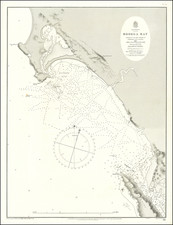
Rare early map of Humboldt, California, showing roads, trails, rail roads, lighthouses and the Redwood Timber Belt, lithographed in San Francisco By Galloway Litho. Co.
The map is from a collection of maps deaccessions from the Atchison Topeka & Santa Fe Railroad in the 1980s and the annotations were likely done by an ATSF engineer or one of the companies acquired by the ATSF.
The map was annotated to show the proposed lines for three railroads, with a note that the "possible line to Reddding -- doubtful!" The Hoopa Vlley Indian Reservation and Camp Gaston are shown and townships are named.
The map is quite rare. An 1881, 1898 and 1903 edition are listed in OCLC (one recorded example of each). Lentell seems to have revised the map in later years, which was republished by Britton & Rey.
![[ Gold Rush Era Sacramento ] Chart of the Sacramento River From Suisun City to the American River California . . . 1850](https://storage.googleapis.com/raremaps/img/small/98242.jpg)
![[San Juan Capistrano to San Onofre] Capistrano Quadrangle](https://storage.googleapis.com/raremaps/img/small/83563.jpg)