This item has been sold, but you can enter your email address to be notified if another example becomes available.


|
||

|

|
|

|
Stock# 31600df
Description
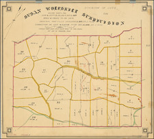
Detailed early map of the townsite of Redondo, published at about the time of its incorporation in 1892, almost certainly one of the earliest extent printed maps of Redondo Beach.
The earliest printed map of Redondo Beach would seem to have been published in 1887 by William Hammond Hall in San Francisco.
The map shows a detailed town plan, streets, the original 3 piers, Hotel Redondo and Redondo High School (founded in 1905, but likely laid out on the original plan for the town much earlier than 1905.
The map is apparently unrecorded, with no record of the map appearing in OCLC or any reference we have located.. It was acquired as part of a Southern Pacific Railroad collection originally deaccessioned in the 1980s.
Condition Description
Some discoloration to one half of the map.