|
||

|

|
|

|
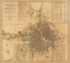
Exceedlingly rare map of Mexico, pub;ished by Juan Valdes y Cueva in Mexico City, with the printing apparently done in Paris.
The map is a fantastic large format illustration of Mexico, colored by state. The map focuses on the major cities and princpal lines of transportation, and includes topographical features such as mountains, lakes and rivers.
At the left side of the map, a series of insets illustrates the tallest mountains in Mexico, a list of Mexico's states, noting the population o each state, the size, capital city of each state and the population of each capital city. There is also an inset map of the Valley of Mexico and a profile showing the change of elevations of the the railroad line from Mexico City and Toluca, Puebla and Vera Cruz.
Based upon the size ( 7.5 feet by 5 feet ) and the style of the map, we surmise that it was intended as a school map for primary school instructional purposes. The formating of the map is quite interesting, including the inset of the Valley of Mexico and comparative mountains, images popularized by Humboldt on his landmark map of Mexico.
While little can be found about he maker of of the map, Juan Valdes y Cueva, we suspect that the map was designed to accompany his Rudimentos de geografía universal y particular de Méjico: para uso de los niños mexicanos : obra de texto arreglada para uso de las escuelas : geografía infanti, an instructional book written to teach geography to young children, published in Mexico in 1891, for which we were able to locate only 1 copy, in the Biblioteca National de Mexico.
Valdes also published a very rare directory of Mexico with maps, entitled Directorio Mexicano. Directorio Comercial, Agricola, Industrial, Profesiones, Artes y Oficios de las Principales Poblaciones de la Republica Mexicana para el año de 1887.
The map is of the utmost rarity, with no examples listed in OCLC.
![(Texas) Denkschrift über eine Reise nach Nord-Mexiko, verbunden mit der Expedition des Obersten Donniphan, in den Jahren 1846 und 1847. Von Dr. A. Wislizenus. Aus dem Englischen übertragen von George M. von Ross. Mit einem wiffenschaftlichen Anhange und drei Karten. [Description of a voyage to northern Mexico connected with Colonel Doniphan's expedition in 1846 and 1847 By Dr. A. Wislizenus. Translated from the English by George M. von Ross. With a scholarly appendix and three maps.]](https://storage.googleapis.com/raremaps/img/small/88574.jpg)
![(Panoramic photograph) Camp Travis, Tex. 9/8/1918 East Side [WWI Camp Travis, near San Antonio, Texas, African American Troops]](https://storage.googleapis.com/raremaps/img/small/87312.jpg)