


|
||

|

|
|

|
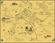
Fine example of this rare map of New Mexico Territory, the only obtainable commercial map to illustrate New Mexico Territory in its early configuration.
The map appeared in the extremely rare Rogers & Johnston Atlas of the United States. The map was derived from the momumental and equally rare wall map, an historic collaboration between Professor Rogers, and American, and the Johnston publishing house in Britain.
The map is colored by counties and shows a number of interesting details, including towns, springs, Indian details, topographical information, forts, mountains, etc. A portion of Southern Colorado appears in New Mexcio, as does all of Arizona and Las Vegas, Nevada. This map has become virtually unobtainable, with the last dealer catalogue appearance in 1988 (George Robinson).
![[ Exceptional original hand-color with highlights in gold ] Typus Aspectuum Oppositionum Et Coniunctionum Etz In Planetis](https://storage.googleapis.com/raremaps/img/small/81866.jpg)
![[San Juan Capistrano to San Onofre] Capistrano Quadrangle](https://storage.googleapis.com/raremaps/img/small/83563.jpg)