This item has been sold, but you can enter your email address to be notified if another example becomes available.


|
||

|

|
|

|
Stock# 28804
Description
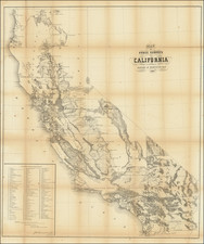
Detailed map of part of Santa Clara County, from Thomson & West's Historical atlas map of Santa Clara County, California. Compiled, drawn and published from personal examinations and surveys by Thompson & West, San Francisco.
The map covers Rancho Laguna Seca, San Juan Bautista Narvaez Rancho. Rancho de los Captiancillo; Rancho San Vicente, Uvas Rancho, etc.
The maps include land owner names, Rancho and Pueblo lands, street names, public buildings, subdivisions, etc.
One of the earliest obtainable maps of the region.