|
||

|

|
|

|
A Fascinating Pair of World maps from Knechtsteden Abbey in Germany's Rhineland, offered together as a pair.
Kloster Knechsteden
The following two maps came from the Kloster Knechsteden, an abbey of Premonstratensian Canons, founded in 1138, near Dormagen, in the German Rhineland. The abbey, considered to be a masterpiece of Romanesque architecture, increasingly became an important center of faith in the Archbishopric of Cologne. Kloster Knechtsteden rose to particular prominence when its abbot, Aegidus of Hunshoven (served, 1573-99), played an instrumental role in the successful battle to keep the Archbishopric within the Roman Catholic faith. The abbey prospered greatly from that point onwards and its activities were greatly expanded under the leader- ship of Abbot Peter Gillrath (served from 1666 to 1678), and a sizeable library was formally established early in the 18th century.
Sadly, in 1794, the abbey was sacked by Napoleon Bonaparte's troops, all of its archives were destroyed, and much of its library was dispersed. As a result, today little is known about the academic activities that were known to have occurred at the abbey. However, Kloster Knechtsteden was likely an ideal environment to foster the production of maps and geographical studies, located in the Rhineland, a major crossroads of intellectual discourse during the period in question.
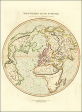
[Manuscript Double Hemisphere Map on Polar Projection]. [Kloster Knechtsteden, Germany, circa 1600].
Manuscript, pen and ink with watercolor additions, consisting of two sheets mounted on a larger piece of paper (some soiling and toning), 17 x 24 inches.
Manuscript double hemisphere map of the world on a polar azimuthal projection, reflecting cartographic details from the 1580s, likely prepared in the first decades of the 17th Century.
This curious map consists of a world map in two hemispheres on a azimuthal polar projection. True to the cartography of the period, the southern hemisphere is dominated by a massive "Terra Incognita Australis", the great mythical southern continent which extended north to Tierra del Fuego in the West and towards the islands of Indonesia in the East. The depiction of the Northern Hemisphere is likewise typical, with East Asia assuming the form common to contemporary maps, while eastern North America assumed a form that predated the discoveries of Samuel de Champlain and John Smith in the early 1600s.
The map is drawn on two pieces of paper and laid down on a larger sheet, which was seemingly folded once and bound into a folio binding. The map would also appear to have been the work of more than one hand. The two map hemispheres are meticulously laid out on a polar projection, with what appears to be a second grid of red lines underlying the polar projection. The initial outline map of the world appears to have been drawn on the original projection, while the wash colors were subsequently added to distinguish different regions.
For detailed images of each hemisphere:
- Southern Hemisphere: www.raremaps.com/gallery/enlarge/27497a
- Northern Hemisphere: www.raremaps.com/gallery/enlarge/27497b
The late Renaissance polymath Guillaume Postel (1510-81) produced the first world map on a polar azimuthal projection in 1581. The projection was first brought to a wider audience by Cornelis De Jode's world map of 1593. During this period, the visually striking and technically challenging nature of the projection fascinated scholars throughout Europe, and the present map appears to be an effort by the monks of Kloster Knechtsteden to provide their own interpretation of the projection.
The lower corners of the sheet that features the southern hemisphere includes inscriptions drawn from annotations on a globe made by Rumold Mercator (circa 1580s), described in the article 'Un precieux Globe terrestre en Cuivre Jaune Construit par Pierre Plancius', in the Annales de L'Academie Royale d'Archeologie de Belgique, vol. 51 (Brussels, 1898), p.477. The notes include a discussion of Marco Polo (Paulo Veneto) and references to passages on Mercator's globe, including:
- Vastissimas hic esse regiones ex M. Pauli Veneti et Ludovico Varto- manni scriptis peregrinationibus liquido constat. ("The voyage of Marco Polo and of Ludovico Varthema makes it certain that an enormous territory exists here.") This quote also appears on the Van Langren / Arnoldus Florentius Globe of 1585.
- Provincia aurifera. ("Land of Gold"), another reference to Marco Polo's Beach.
- catens aromatibus. ("A region flowing with spices"), also from Marco Polo.
- Inter los Romeros et S. Laurenty insulas vehemens admodum est versus ortum et occasus fluxus et refluxus oceani. Between the islands of los Romeros and St. Lawrence, there is a very strong flow and ebb of the ocean towards the east and west. A similar phrase appears on the world maps of Plancius (1594), Le Clerc (1602), Van Deutecum (1605) and Van Der Keere (1608).
- [ Psitacorum regio], sic a Lusitanis appelata ob incredibilem earum avium magnitudinem. Drawn from Mercator's globe of 1541, this translates as: [Region of] so called by the Portuguese because of the incredible size of these birds. The section in [ ] is shown on Mercator's Globe, but not on this manuscript map.
Significant evidence on the map links it to Kloster Knechtsteden. Curiously, a dot on the Northern Hemisphere of the map is placed roughly on the location of Knechtsteden. Furthermore, the signature in the margin of the sheet onto which the map is pasted suggests that the map came into the possession of F.J.W. Brandt, who is thought to have been a monk resident at Kloster Knechtsteden at the end of the 17th Century. Preliminary research suggests that Brandt was a native of Düsseldorf, and died in Hungary in 1696. A note accompanying the following manuscript map (acquired with this map) suggests that he was resident at the abbey in 1692.
This intriguing map is a unique glimpse into the monastic academic milieu of the Late Renaissance and is certainly worthy of further study.
![[Pacific Ocean Centric World Map] Mappe-Monde Sur la Projection de Mercator Carte Encyprotype Dediée et Présentée à Monsieur](https://storage.googleapis.com/raremaps/img/small/69294.jpg)
![(Second World War) Newsmap -- Monday, November 23, 1942 [on verso:] Life Save #2 Winning Friends - Helping People](https://storage.googleapis.com/raremaps/img/small/94937.jpg)
![[ Charting Hall's Quest For The North Pole ] Die Entdeckungen der Amerikanischen Nordpolar-Expedition unter Kapitan C.F. Hall 1871-1873. Reduction der vom Hydrographic Office, U.S. Navy harausgegebenen grossen Karte.](https://storage.googleapis.com/raremaps/img/small/98478.jpg)