|
||

|

|
|

|
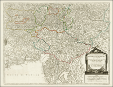
Scarce regional map of the northern part of the Turkish Empire in Europe.
The map extends from Kiev and Cracow in the north to Dalmatia, Albania, Macedonia and the Gulf of Marmora in the south, centered on Transylvania and the course of the Danube.
Nicholas Sanson (1600-1667) is considered the father of French cartography in its golden age from the mid-seventeenth century to the mid-eighteenth. Over the course of his career he produced over 300 maps; they are known for their clean style and extensive research. Sanson was largely responsible for beginning the shift of cartographic production and excellence from Amsterdam to Paris in the later-seventeenth century.
Sanson was born in Abbeville in Picardy. He made his first map at age twenty, a wall map of ancient Gaul. Upon moving to Paris, he gained the attention of Cardinal Richelieu, who made an introduction of Sanson to King Louis XIII. This led to Sanson's tutoring of the king and the granting of the title ingenieur-geographe du roi.
His success can be chalked up to his geographic and research skills, but also to his partnership with Pierre Mariette. Early in his career, Sanson worked primarily with the publisher Melchior Tavernier. Mariette purchased Tavernier’s business in 1644. Sanson worked with Mariette until 1657, when the latter died. Mariette’s son, also Pierre, helped to publish the Cartes générales de toutes les parties du monde (1658), Sanson' atlas and the first French world atlas.
![[Aegean Sea - Greece - Turkey] Carte Reduite de L'Archipel Pour servir aux Vaisseaux du Roy . . . 1738](https://storage.googleapis.com/raremaps/img/small/77482.jpg)
![[Kiev Region] Li Palatinati di Braclaw e Kiowia Tratta dell' Atlante Polacco del Sigr Rizzi Zanoni . . . 1781](https://storage.googleapis.com/raremaps/img/small/78390.jpg)