


|
||

|

|
|

|
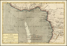
Rare highly detailed map of of the Northwestern part of Africa, extending from Alexandria and the Straits of Gibraltar in the north to Equatorial Africa, centered on Senegal and the Sahara Desert.
De Fer's map is an exceptional large format presentation of the region, which includes some fascinating illustrations of local flora and fauna, including a man gathering ivory tusks, a man climbing a coconut tree, illustrations of a scorpion, crocodile, ostrich, lion and elephant, native huts, bow and spear hunters, and a native village.
This fascinating map includes exceptional detail in the map and excellent survey of the coordinates of 20 major cities. The map includes a number of annotations, including the Portugese discovery of the Azores in 1449, the discovery of the Canary Islands in 1449, the discovery of the Cape Verde Islands in 1455 and the discovery of Isle de Fer in 1664. The details within the map are quite remarkable, naming more than 2 dozen kingdoms and identifying dozens more towns, ports, islands, Lakes and other fine details. The Villages and Habitations of a number of different Arab Tribes and Bedouins are noted, along with similar notes in Sub-Saharan Africa. Great attention is given to the topography.
The map is quite rare on the market. We found no prior references to the map in any auction records or dealer catalogues.
Nicholas de Fer (1646-1720) was the son of a map seller, Antoine de Fer, and grew to be one of the most well-known mapmakers in France in the seventeenth century. He was apprenticed at twelve years old to Louis Spirinx, an engraver. When his father died in 1673, Nicholas helped his mother run the business until 1687, when he became the sole proprietor.
His earliest known work is a map of the Canal of Languedoc in 1669, while some of his earliest engravings are in the revised edition of Methode pour Apprendre Facilement la Geographie (1685). In 1697, he published his first world atlas. Perhaps his most famous map is his wall map of America, published in 1698, with its celebrated beaver scene (engraved by Hendrick van Loon, designed by Nicolas Guerard). After his death in 1720, the business passed to his sons-in-law, Guillaume Danet and Jacques-Francois Benard.
![X. b [Congo]](https://storage.googleapis.com/raremaps/img/small/93299.jpg)
![[Moroccan Coast -- Agadir, Essaouira, Safi] Afbeeldinge nae't leven der Zeecusten van Barbarien, van de C. Cantin zuijdwaert tot verbij de C. de Geer, mitsgaders de gelegentheijt van't eijlant Mogodor, alles op zijne rechte Streckinge en hoochte gestelt](https://storage.googleapis.com/raremaps/img/small/62163.jpg)