


|
||

|

|
|

|
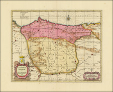
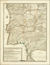
Decorative full color example of De Fer's map of Portugal and the Spanish Frontiers, originally published in 1703 by Nicolas De Fer, the Geographer to the King of France.
Highly detailed map, extending to Strait of Gibraltar and northern Morocco in the south, Granada, Toledo and Burgos in the east, Pontevedre and Astorgas in the north and Portugal in the west, with a large compass rose and decorative cartouche.
The map was engraved by Starckman and published by Charles Louis Desnos, who sucessor to the Nicolas De Fer's business, following the death of De Fer's son-in-law, Guillaume De L'Isle.
Nicholas de Fer (1646-1720) was the son of a map seller, Antoine de Fer, and grew to be one of the most well-known mapmakers in France in the seventeenth century. He was apprenticed at twelve years old to Louis Spirinx, an engraver. When his father died in 1673, Nicholas helped his mother run the business until 1687, when he became the sole proprietor.
His earliest known work is a map of the Canal of Languedoc in 1669, while some of his earliest engravings are in the revised edition of Methode pour Apprendre Facilement la Geographie (1685). In 1697, he published his first world atlas. Perhaps his most famous map is his wall map of America, published in 1698, with its celebrated beaver scene (engraved by Hendrick van Loon, designed by Nicolas Guerard). After his death in 1720, the business passed to his sons-in-law, Guillaume Danet and Jacques-Francois Benard.