This item has been sold, but you can enter your email address to be notified if another example becomes available.


|
||

|

|
|

|
Stock# 24738
Description
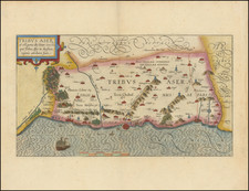
Fine example of this extremely rare map of the Holy Land, based upon a larger map of the Holy Land by Wolfgang Wissenberg.
Franciscus's map of the Holy Land is a remarkable combination of bird's eye view and map. Depiction of the buildings in a number of towns, including Jerusalem, can be seen. A portion of the Jew's Exodus from Egypt can be shown, including scenes on both sides of the Red Sea and extending to the Jordan River, with the wandering Jews depicted in the style of military columns.
The map includes an elaborate cartouche incorporating cupids and tritons. Numerous towns, tribes and encampments delineated. The map was later copied by Fernando Bertelli in 1563.
Condition Description
Nice example, with large extended margins added, as assembled to be bound into a Lafreri school atlas
Reference
Tooley 434.Laor 249.
![[ Genesis / Creation ] De Schepping der Wereldt Volgens de Beschryving van Mozes. 1 Plaat [in set with] De Schepping der Wereldt Volgens de Beschryving van Mozes. 2. Plaat](https://storage.googleapis.com/raremaps/img/small/101543.jpg)
![Tab. IV. Asiae in qua Mesopotamia, Syria, Arabia Petrea ac Deserta . . . [Shows Cyprus]](https://storage.googleapis.com/raremaps/img/small/97732.jpg)