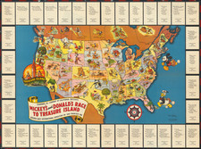
|
||

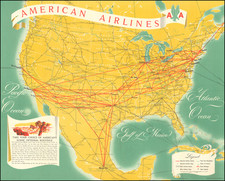
|

|
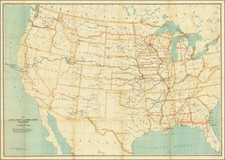
|

|
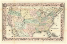
Gorgeous 4 sheet map of the United States from Flemming's Handatlas, perhaps the single best German atlas of its era for treatment of the American West, generally including maps of the Northwest Coast of America, regions west of the Rockies, southwest and a Texas map often referred to as the German Arrowsmith. Texas is oversized, a large portion of Indian Territory is shown as New Mexico, Indian Territory extends to Kansas, Colorado and Southern Wyoming, and Utah Territory runs to Laramie. Minnesota Territory extends west to the Missouri and Nebraska Territory runs to Canada and the Rockies. A key shows the states & territories, w/populations, number of counties & size. Too much Indian & western detail to mention. A flawless expertly joined example.