


|
||

|

|
|

|
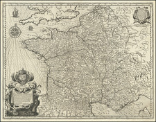
Nice example of Blaeu's map of Ancient Galle, based up the Commentaries of Julius Caesar.
Ortelius based this map of ancient France on information from Caesar's De Bello Gallico. It is engraved to show the mountains, rivers and forests with only a few ancient place names. The names of famous people and tribes of Gallia, as described by Caesar, are listed at sides. It is a handsome map with tiny ships sailing in the seas and three strapwork cartouches containing the title, scale and dedication, all surrounded in an elaborately engraved border.
Willem Janszoon Blaeu (1571-1638) was a prominent Dutch geographer and publisher. Born the son of a herring merchant, Blaeu chose not fish but mathematics and astronomy for his focus. He studied with the famous Danish astronomer Tycho Brahe, with whom he honed his instrument and globe making skills. Blaeu set up shop in Amsterdam, where he sold instruments and globes, published maps, and edited the works of intellectuals like Descartes and Hugo Grotius. In 1635, he released his atlas, Theatrum Orbis Terrarum, sive, Atlas novus.
Willem died in 1638. He had two sons, Cornelis (1610-1648) and Joan (1596-1673). Joan trained as a lawyer, but joined his father’s business rather than practice. After his father’s death, the brothers took over their father’s shop and Joan took on his work as hydrographer to the Dutch East India Company. Later in life, Joan would modify and greatly expand his father’s Atlas novus, eventually releasing his masterpiece, the Atlas maior, between 1662 and 1672.
![Le Costa della Francia sul mare Oceano [The Coast of France on the Oceanic Sea]](https://storage.googleapis.com/raremaps/img/small/90844.jpg)
![(Modern France) [Tabula Moderna Francie]](https://storage.googleapis.com/raremaps/img/small/64753.jpg)
