|
||

|

|
|

|
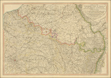
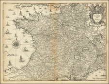
Rare, two-sheet map of France published by Domenico Rossi and following the bold, Italian, engraving style of his predecessor Giacomo Cantelli.
The map provides a detailed look at the Atlantic coast of France, from the Basque Country northwards to the English Channel. Coastal and inland detail are provided, with cities, rivers, borders, and more all shown. Each of the sheets includes a decorative, Italian-style cartouche.
It is uncommon to see these sheets unjoined, as they would more often have been joined for inclusion in a larger atlas. However, this example is particularly interesting as it preserves the binding instructions and extended titles in the margins.
This map was originally published in Domenico Rossi's Mercurio Geografico. As with most of the maps in the atlas, this map of France was derived from Cantelli's earlier maps. Cantelli was one of the pioneers of 17th century Italian cartography, who would influence the later Italian cartographer Vincenzo Coronelli as well as the French cartographer Nicolas Sanson.
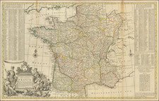
![Generale Caert van Vranckryck [General Map of France]](https://storage.googleapis.com/raremaps/img/small/93273.jpg)