
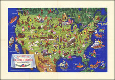
This item has been sold, but you can enter your email address to be notified if another example becomes available.


|
||

|

|
|

|
Stock# 2292
Description
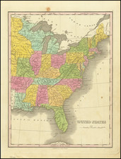
Marvelous map of the US, one year prior to Texas' Independence. The treatment of the oversized 54-40 or fight Oregon Territory, Missouri Territory and the region west of the Mississippi is especially interesting. Most notable are the Spanish names appearing along the western porion of the Southern Mississippi River for the regions which would become Missouri and Arkansas and Missouri, including Lawrence, Cape Girardeau, Howard and St. Louis. The map is rich with Indian names, far more than typical. A striking map from a fascinating time period in American history.
![[ Southern Railroads ] Railroad Map of the Southern States Shewing the Southern & Southwestern Railway Connections With Philadelphia. 1862 . . . Prepared by Thomas Kimber Jr., Chairman of the Committee on Inland Transportation of the Board of Trade of Philadelphia](https://storage.googleapis.com/raremaps/img/small/103211.jpg)
![The Eagle Map of the United States Engraved For Rudiments of National Knowledge. 1833. [with:] Rudiments of National Knowledge, Presented To The Youth Of The United States, And To Enquiring Foreigners. By A Citizen Of Pennsylvania.](https://storage.googleapis.com/raremaps/img/small/86933.jpg)