|
||

|

|
|

|
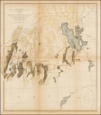
Unrecorded Wall Map of Butte, Montana, showing the original townsite, additional subdivisions, neighboring townships and other fine details.
Highly detailed and unusual map of the area around Butte, Montana, on a scale of 500 feet: 1 inch, a much larger and scale than other printed maps of the area around Butte. While mining maps of the Butte area appear occasionally on the market, this wall map is one of the earliest maps to focus on townships, subdivisions and other above land features. Even early hospitals and other public buildings are shown, along with several railroad lines. The map also shows several hundred mining claims in the area around Butte, along with numerous other features of the area including, smelters, and other importan features in the mining process.
This map was prepared by Harper & McDonald, the primary publishers of a the series of Butte mining maps which began in 1885 and continuedf for more than 20 years. However, this map is prepared on a much larger scale and includes very different details. Most of the mining maps are on a scale of 1:14,500 or greater, whereas the present map is 1 inch : 500 feet. The map is clearly not from the same plate as the mining maps. Also, unlike the mining maps, the present map was published in Chicago by Rand McNally & Co.
The earliest Butte area mining maps were issued in 1885 by Baker & Harper and printed by H.B. Stranahan, in Cleveland. These maps about 25 x 41 inches. A second smaller edition was issued in 1893. In 1901, a third edition was printed, with the printer and publisher changed to Harper & MacDonald of Butte, Montana, with the size increased to 26 x 36 inches. In 1907, the name was changed to Harper, MacDonald & Co and the size of the map grew to 38 x 50 inches. This 1913 edition is significantly updated, with a different size, many new claims, a different geographical orientation further north of the 1907 edition and with a different set of mining engineers receiving credit for the map. This edition also bears the name E.P. Noll of Philadelphia. A 1916 edition was also issued, with the Noll name changed to C.S. Hammond.
Examples of the Butte mining map sell periodically at auction and through dealer catalogues (a 1907 Butte Mining map sold at Cowan's in 2007 for $2300). We have been unable to locate any examples of the present map being offered for sale. No examples of the 1898 edition of this map appear in OCLC. The DeGolyer Library @ SMU appears to hold a pocket map version of the map, dated 1899, although there is no mention of the Rand McNally imprint and the map appears to be a bit smaller (OCLC: 28347181).
Butte began as a mining town in the 1870s, in the Silver Bow Creek Valley. In 1879, the central business district burned to the ground and the town was thereafter reconstructed from the ground up, using brick and stone.
While initially only gold and silver were mined in the area, the advent of electricity created a massive demand for copper, which was abundant in the area. The resulting boom turned Butte into "the Richest Hill on Earth". Three men fought for control of Butte's mining wealth. These three "Copper Kings" were William A. Clark, Marcus Daly, and F. Augustus Heinze. In 1899, Daly joined with William Rockefeller, Henry H. Rogers, and Thomas W. Lawson to organize the Amalgamated Copper Mining Company. Not long after, the company changed its name to Anaconda Copper Mining Company (ACM). Over the years, Anaconda was owned by assorted larger corporations. In the 1920s, it had a virtual monopoly over the mines in and around Butte.

![[Uncaptioned image of two figures seated in front of a tipi, mounted albumen print]](https://storage.googleapis.com/raremaps/img/small/78744.jpg)
![Map of the Missouri Pacific and St. Louis, Iron Mountain and Southern Railway and Connections [Missouri Pacific Railway. St. Louis & All Points East Chair Cars Free Fast Mail Route]](https://storage.googleapis.com/raremaps/img/small/91606.jpg)