The item illustrated and described below is sold, but we
have another example in stock. To view the example which
is currently being offered for sale, click the
"View Details" button below.


|
||

|

|
|

|
Stock# 21844
Description
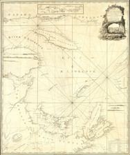
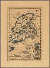
Striking map of Cape Breton Island from 1747 from the London Magazine--one of the earliest American maps to appear in this publication.
Numerous islands, bays and harbors are identified. Shows details of the entire island with many names along the coast and interior. The lower portion of the map is filled with a view of fishermen, a trader, boat and a trading post in the background. Also shows I. St. Paul. The title is contained in a unique British flag cartouche. The first work of Thomas Kitchin appeared in 1745, making this an early example of his work.
Reference
Jolly Lond-24