|
||

|

|
|

|
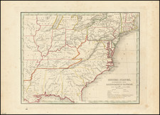
Second state of Desilver's map of the United States, immediately following th change over to his trademark decorative border.
Desilver was the successor to Thomas Cowperthwaite & Company in publication of Mitchells New Univesal Atlas. The most notable change from earlier editions of the map is the creation of Kansas Territory, extending to the Rocky Mountains and the creation of Nebraska Territory, extending to Canada and the Rocky Mountains. The map retains many of its marvelous characteristic details, including Indian Tribal names, early settlements, explorer routes, gold, silver and copper mines in California and New Mexico Territory, Great S0panish Trail, Oregon Trail, extensive early roads in Oregon and Washington Territories and California, many early forts and settlements, etc.
Includes insets of the Gold Regions and Washington DC. Many early railroads are shown, along with Battlefields in the Eastern United States. Many early forts appear in Texas.
![[ Early US Map Following Treaty of Peace ] Etats-Unis De L'Amerique Divises en 13 Provinces avec leurs Limites, suivant le Traite de paix fait le 20 Janvier 1783.](https://storage.googleapis.com/raremaps/img/small/103575.jpg)
![[Eurpean and American Air Routes] TWA Trans World Airline U.S.A. • Europe • Africa • Asia Air Routes](https://storage.googleapis.com/raremaps/img/small/89027.jpg)