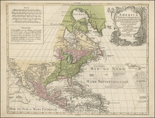
A classic map of North America immediately after the American Revolution from Harrison's scarce large format atlas. The map is based upon the work of D'Anville, but with improvements. Florida is still an Archpelago, with its border extending to the modern KY-TN border. The Mississippi is accurately depictied, with extensive knowledge of its drainages. There is considerable detail and French and Indian settlements on either side of the Mississippi River, extending as far west as Kansas & Nebraska. There is also excellent detail in New Mexico and Southern Arizona. Curiously, a series of lakes and rivers west of Lake Superior still hints at the prospects of a water passage to the west. Full of Indian settlements, early forts and other details.
![Amerique Septentrionale divisee en Ses Principales parties . . . . 169 [California as an Island]](https://storage.googleapis.com/raremaps/img/small/91231.jpg)
![Amerique Septentrionale divisee en Ses Principales parties . . . . 1692 [California as an Island]](https://storage.googleapis.com/raremaps/img/small/95812.jpg)
![Nord-Amerika [North America]](https://storage.googleapis.com/raremaps/img/small/91328.jpg)