|
||

|

|
|

|
Stock# 91328
Description
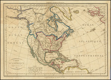
Fantastic and rare mid-19th-century German map of North America, showing a number of interesting state configurations in the western portion of the United States.
The map shows Canada, Mexico, and the U.S. In the U.S., various features of interest include a joined Arizona and New Mexico, a Kansas territory reaching the Rockies,and a wide configuration of Utah Territory, where it encompasses most of Nevada. Further north, Minnesota is still shown as a territory even after it had been admitted to the Union, and the map includes an oversized Nebraska Territory. Native American tribes are named throughout.
This map was originally published in J. M. Ziegler's Geographischer Atlas uber alle Theile der Erde.
Condition Description
Two-stone lithograph with original hand-color, in outline. Minor foxing.
![A New Map of North America Shewing its Principal Divisions, Chief Cities, Townes, Rivers, Mountains &c. Dedicated to His Highness William Duke of Gloucester [California as an Island]](https://storage.googleapis.com/raremaps/img/small/100578.jpg)
![[Educational Map] North America](https://storage.googleapis.com/raremaps/img/small/68773.jpg)