|
||

|

|
|

|
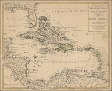
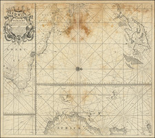
Detailed map of Puerto Rico, Hispaniola, the Virgin Islands, Windward Islands and the Northwest Coast of South America, showing the route of Robert Harcourt through the region.
Robert Harcourt first sailed to Guyana in 1609 where, with his brother Michael, he established a settlement. After a few years, the settlement failed. Harcourt published a book on his voyage, but was unable to raise enough capital to revive the venture. In1626, Harcourt and Captain Roger North founded the Guyana Company. Two years later, he sailed for Guyana, where he is thought to have died shortly thereafter. The map was originally prepared to illustrate the Dutch translation of the book on Harcourt's first voyage.
In all, Vander Aa issued 130 translations of important 15th, 16th and 17th Century Travel Narratives to the America, Africa and Asia, which were issued in 28 volumes in the early part of the 18th Century. Many of the narratives are either unobtainable or extremely rare in their original formats. Striking full color example of this beautifully engraved map.
Pieter van der Aa (1659-1733) was a Dutch mapmaker and publisher who printed pirated editions of foreign bestsellers and illustrated books, but is best known for his voluminous output of maps and atlases. Van der Aa was born to a German stonecutter from Holstein. Interestingly, all three van der Aa sons came to be involved in the printing business. Hildebrand was a copper engraver and Boudewyn was a printer.