|
||

|

|
|

|
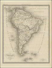
Süd- America, designed and drawn by F. von Stulpnagel, is an 1880 map of South America published by Justus Perthes in Gotha. It methodically delineates the complex political and territorial divisions of South America during that period, featuring details on the Spanish American Republics, the Empire of Brazil, and other geopolitical entities, showcasing an intricate web of provinces, departments, and territories.
This map is particularly notable for its detailed representation of the administrative divisions within various South American countries. It lists provinces and departments within the Spanish American Republics, the Empire of Brazil, and other nations, capturing a snapshot of the continent’s political organization. Notable inclusions are Venezuela’s 13 provinces, Ecuador’s 10 provinces, and Peru’s 13 departments. It presents a detailed overview of a continent marked by both diversity and unity, intricately woven into a singular geographical tapestry.
A deeper analysis of Süd- America unveils the nuanced complexities of a continent in the throes of political, cultural, and territorial redefinition. Each listed province, from Venezuela's Carabobo to Chile's Aconcagua, is a testament to the localized identities that were becoming increasingly pronounced. The mention of "Vereinsstaat Columbia," indicative of the United States of Colombia, underscores a transient moment in history before the country would become the Republic of Colombia.
![La Florida [with] Guastecan [with] Peruviae Avriferae Regionis Typus](https://storage.googleapis.com/raremaps/img/small/89451.jpg)