|
||

|

|
|

|
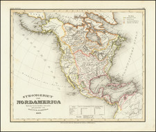
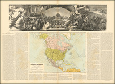
Fine example of Brue's rare and important 1843 Brue maps of North & South America, in an original slipcase.
Brue's map of North America is a landmark map in North American history, being the first map to incorporate information derived from Jedediah Smith. As noted by Wheat:
In 1833 the widow of A.H. Brue . . . supervised the publication in Paris of a monumental map of North America . . . on which a number of new items appeared. This map was primarily of the Lewis and Clark-Stephen H. Long type, but in the southwest the R. Timpanagos was declared to be the "Source principale du Multomah," a really new idea. The great southeastern branch of that river, connected with Lake Timpanagos by a dotted line, is labled R. Mackay," after one of the Hudson's Bay Company's traders, while the southern branch, or R. Calapaio, is stated to have its "Source pres de l'ocean." Roquefeuille de Morineau is declared the authority for the statement about the Sacramento River to the effect that it was navigable for fifty leagues "pour de grands bateaux."
That the tales of Jedediah Smith's journeyings had reached France is shown on this 1833 Brue map by "Mt. St. Joseph Couvert de Neige au mois de Mail," in what is now Nevada, where also occur the legends "Pays desert, aride et sablonneux, sans gibier et habite par quelques bands d'indiens," and "Pays peuple, en quelques endroits d'un grand nobre d'indiens, qui vivent de poissons et de graines." But what best evidences Smith is the dotted line of the river, near R. Ashley, called R. Adams at its head, which finally runs into the Colorado from the north near its mouth. For the most of its route this stream is a dotted line but it is labled the "Seeds of Keeder," Smith's name for hte Green [River]. Smith's cave of salt is shown near it, and of the river the map states, "dont la source est inconnue elle renferme beaucoup de rapides." . . . the Rio de las "Pirami" des Sulfereas bears the most interesting note of all-- "Probablt. le Seeds Keeder de Smith." Here, then, is the first cartographic mention of the great explorere, by the same mapmaker wh was to show his route to California a year later."
The first edition of the map was used and reproduced in part by the Alaskan Boundary Commission. The present example retains the original Jedediah Smith details and also includes some noteworthy updates, including a clear depiction of the Republic of Texas and updated boundaries withing the United States. California is confined to a narrow channel along the coastline and Russian America is shown quite prominently. The map also provides tremendous detail in the Canadian Transmississippi West, synthesizing the information from the Hudson's Bay Company maps and the maps of Arrowsmith and Wyld.
Brue's map is of the utmost rarity. There are no recorded examples of the 1845 edition and only 2 earlier editions are know in US Institutional collections. OCLC locates the following examples of the map, 1833 edition (Wurttembergische Landesbiblitherk, Bibliotheque Nationale De France), 1835 edition (Yale), 1863 edition (British Library, Danish National Bibliothek), 1840 edition (UC Berkeley), 1872 edition (Univerity of Chicago), and 1874 edition (University of Chicago).
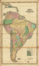
The second map is a remarkably detailed map of South America of equal rarity. The map depicts in great detail the newly forming independent nations of South America at the mid-point of the Century of Revolution in South America.
Andre Hubert Brué was a French geographer and cartographer. Born in Paris, he served in the French Navy, joining the Baudin expedition to the Pacific (1800-1804). After his sea service, Brué applied his navigation and charting skills to creating finely-crafted maps, which were renowned for their crisp engraving and accuracy. He drew directly on the copper of the plate, creating what he called encyprotypes. He is best known for the Atlas universal de géographie physique, politique, ancienne et moderne.

![[ Oil & Gas in Texas and Louisiana ] Gulf Coastal Region Texas and Louisiana Showing Oil, Gas & Sulphur Fields & Prospects Pipe Lines & Refineries](https://storage.googleapis.com/raremaps/img/small/101409.jpg)