|
||

|

|
|

|
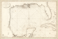
Scarce separately issued map of Central America, which is also part of a 6 map set showing the Gulf Coast & Caribbean, but is most often found as a separate map.
Extends from Provincia Honduras to Nova Granadae and St. Martha, centered on Panama & Costa Rica. Highly detailed. Gorgeous old color example of this scarce map of Central America, one of the most detailed of the period.
The Ottens brothers, Reiner and Joshua, operated a successful printing partnership in the mid-eighteenth century (fl. 1726-1765). They began the venture in 1726, publishing maps and other prints as “R & I Ottens.” They specialized in the reprinting of others’ work, especially Guillaume De L’Isle. In 1750, Reiner died; his soon, also Reiner, took his place, but the firm began listing their works as “Joshua & Reiner Ottens.” The firm lasted until Joshua’s death in 1765. Joshua’s widow, Johanna de Lindt, sold their remaining stock of plates in 1784.
![[Martinique, Guadaloupe, Dominica and Marie Galante] . Suite des Isles Antilles 2. Partie](https://storage.googleapis.com/raremaps/img/small/81614.jpg)


![Carte Reduite des Isles Antilles Dressee au Depost des Cartes et Plans de la Marine… [Large Inset of Virgin Islands]](https://storage.googleapis.com/raremaps/img/small/68206.jpg)