|
||

|

|
|

|
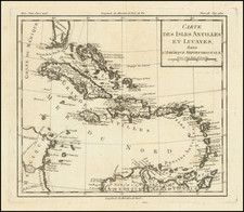
Jacques Nicolas Bellin's Carte Reduite Des Isles Antilles, published in Paris in 1758, stands as a large, expertly engraved sea chart of the Lesser Antilles, reflecting the expertise and precision of French maritime cartography in the mid-18th century.
This chart features a wealth of detail regarding the islands of the Lesser Antilles. Identified are Tobago, Grenada, Saint Lucia, Barbados, Saint Kitts and Nevis, among others, with each island's coastline, significant ports, and inland features depicted. Such comprehensive detail testifies to the surveys conducted by maritime nations during this period.
An intriguing component of this chart is the detailed inset of the Virgin Islands situated on the left, titled "Carte Particuliere des Isles des Vierges". The explicit credit to the English—"Tiree des Anglois"—for this part of the map attests to the multinational nature of cartographic knowledge during this era.
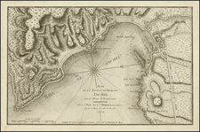
Further enhancing the chart's navigational utility, the upper left portion includes two coastal profiles of Saint Eustatius, providing a visual guide for seafarers approaching this island from different directions. Such profiles were vital navigational aids, aiding mariners in recognizing landforms from sea.
Created by Jacques Nicolas Bellin, a respected engineer for the French Navy and Royal Censor, this 1758 sea chart exemplifies the precision and detail that characterizes his work. With its accurate representation of the Lesser Antilles and the unique addition of coastal profiles, it remains an impressive artifact of 18th-century maritime exploration.
Jacques-Nicolas Bellin (1703-1772) was among the most important mapmakers of the eighteenth century. In 1721, at only the age of 18, he was appointed Hydrographer to the French Navy. In August 1741, he became the first Ingénieur de la Marine of the Dépôt des cartes et plans de la Marine (the French Hydrographic Office) and was named Official Hydrographer of the French King.
During his term as Official Hydrographer, the Dépôt was the one of the most active centers for the production of sea charts and maps in Europe. Their output included a folio-format sea atlas of France, the Neptune Francois. He also produced a number of sea atlases of the world, including the Atlas Maritime and the Hydrographie Francaise. These gained fame and distinction all over Europe and were republished throughout the eighteenth and even in the nineteenth century.
Bellin also produced smaller format maps such as the 1764 Petit Atlas Maritime, containing 580 finely-detailed charts. He also contributed a number of maps for the 15-volume Histoire Generale des Voyages of Antoine François Prévost.
Bellin set a very high standard of workmanship and accuracy, cementing France's leading role in European cartography and geography during this period. Many of his maps were copied by other mapmakers across the continent.
![[ Virigin Islands to Trinidad and Tobago ] A Chart of the Antilles, or, Charibbee or, Caribs Islands, with the Virgin Isles . . . MDCCLXXXIV](https://storage.googleapis.com/raremaps/img/small/103660.jpg)
![[Barbados] Nieuwe Land en Zeekaart van het Eyland Barbados Geleegen in West Inida onder de Caribesse Eylanden. Afgeteekent na de Nieuste Opservatien . . .](https://storage.googleapis.com/raremaps/img/small/60428op.jpg)