|
||

|

|
|

|
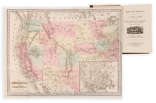
Striking wide margin example of the rare European market variant of the first edition of Colton's map of the United States. One of the most sought after of all 1850s maps of the US and one of the first atlas maps to cover the US from coast to coast. The map is a remarkable compendium of contemporary cartographic information, showing the early Western Territorial configurations. Washington & Oregon Territories extending to the Rocky Mountains, Nebraska extends to the Rockies and Canadian Border, elongated Kanzas extends to Colorado and Wyoming, Utah and New Mexico run from California to Beyon the Rockies. Map shows a post-Gadsden border, early roads, explorers routes, Indians, Forts, proposed USPRR routes & a host of other information, including the location of Capt. Gunnison's death and several of the rejected pre-Gadsden borders. This rare variant edition, in outline color, was apparently only sold on the European market. Minor centerfold stain, else a nice example.